How To
Recipes Big Pic Current Energy Adaptation
Hawaiian Land Divisions

SUBHEAD: A new way to access the Moku and Ahupuaa divisions of the islands of Hawaii.

By Juan Wilson on 30 January 2012 for Island Breath -
(http://www.islandbreath.org/mokupuni/mokupuni.html)
• Modified 26 April 2019. Corrected broken link to Big Island PDF file.


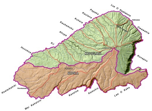
Mokupuni O Kahoolawe
Image above: Ka Mokupuni o Kahoolawe showing Moku and Ahupuaa divisions.

The traditional land divisions of pre-contact Hawaiians was based on the sustainability and self-reliance within community watershed areas (ahupuaa) as well as within bioregions (moku) and lastly individual sovereign islands (mokupuni).  These natural  land divisions  were the  result of the flow of water over the land.

Of course, boundaries were also determined by the political influence and power. We have, to the degree possible, ignored the land divisions based on conquest and private ownership, and kept to the relation of Hawaiians to the aina itself.

In 2007
Jonathan Jan and I began an effort to map the bioregions and watersheds of Kauai and resolve them with the traditional Hawaiian parallels of mokus and auhupaas.

This map work attracted the attention of
Ileialoha Beniamina, chairwoman of the Aha Kiole Advisory Committee. The Advisory Committee was supported by the Western Pacific Regional Fishery Council (under National Oceanic and Atmospheric Administration of the Department of Commerce)

After the mapping of Kauai was completed the  Western Pacific Regional Fishery contracted me to map all the Hawaiian Islands in a similar manner.

In 2010 I did a detailed survey using historical documents, early Hawaiian Maps, USGS survey maps, the support of the Aha Keole Advisory Committee, The Western Pacific Regional Fishery Council, The Kauai Historic Society, and individual accounts by individuals such as Ileialoha Beniamina.

Applied to these sources
I, with help from Jonathan Jay, used the geography of the islands based on 3D GoogleEarth elevations and USGS map data as well as the State of Hawaii GIS data on watersheds, streams and contours. This information was used to tie the traditional information to modern geographic modeling that describe the flow of water over the land.

Jonathan Jay was responsible for the research on Kahoolawe and consulted on other islands as well. I was responsible for all finished map graphics and the subsequent udates.


The resulting work produced files available to the public that include GoogleEarth files, PDF plot files for producing 24"x36" maps, as well as high-resolution bitmap (PNG raster image) files and geographic information system SHP files compatible with Arcview.

After their first report was finished and the maps were completed, the Aha Kiole Advisory Committee became the Aha Moku Council.

Links to those files, by individual islands, are available below. The files can be used for non-commercial use by the public.

If you choose to use these files or publish them, please give credit to the source "IslandBreath.org ©2014". Please do no alter these files without consultation and permission. If commercial use is desired, for example selling printed maps,  contract us for arrangements.

Juan Wilson
www.IslandBreath.org
juan@islandbreath.org
(808) 335-0733
PO Box 949 Hanapepe, Hawaii, 96716-0949


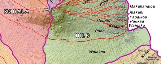
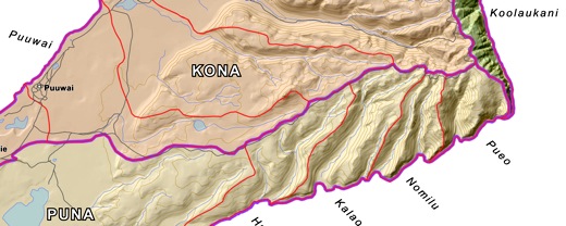
Mokupuni O Hawaii


Image above: Detail of Hawaii (Big Island) traditional land divisions. Click to see whole island.

Available Downloads:
GoogleEarth file .KMZ (60MB) modified 10/7/15
24"x36" Plotfile .PDF (60MB) modified 7/22/16
Hi Rez Raster PNG (6.3MB) modified 7/22/16
Arcview GIS files .SHP ZIP (1MB) modified 10/7/15
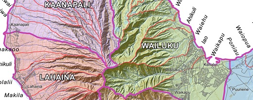
Mokupuni O Maui


Image above: Detail of Maui  traditional land divisions.
Click to see whole island.

Available Downloads:
GoogleEarth file .KMZ (7MB) modified 1/13/11
24"x36" Plotfile .PDF (49MB) modified 5/8/14
Hi Rez Raster File .PNG (17MB) modified 12/6/18
Arcview GIS files .SHP ZIP (1MB) modified 1/27/12
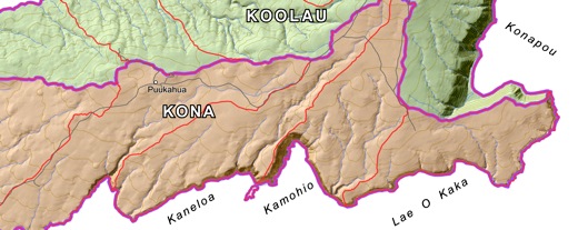
Mokupuni O Kahoolawe


Image above: Detail of Kahoolawe traditional land divisions. Click to see whole island.

Available Downloads:
GoogleEarth file .KMZ (2MB) modified 11/18/10
24"x36" Plotfile .PDF (11MB) modified 8/3/10
Hi Rez Raster File .PNG (3MB) modified 11/1/11
Arcview GIS files .SHP ZIP (.2MB) modified 1/27/12

Mokupuni O Lanai


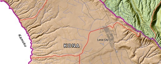
Image above: Detail of Lanai  traditional land divisions. Click to see whole island.

Available Downloads:
GoogleEarth file .KMZ (7MB) modified 11/18/10
24"x36" Plotfile .PDF (30MB) modified 8/3/10
Hi Rez Raster File .PNG (8MB) modified 11/1/11
Arcview GIS files .SHP ZIP (.2MB) modified 1/27/12
Mokupuni O Molokai


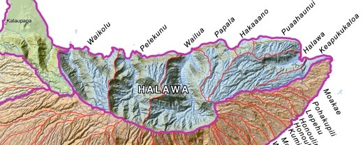
Image above: Detail of Molokai  traditional land divisions. Click to see whole island.

Available Downloads:
GoogleEarth file .KMZ (11MB) modified 11/18/10
24"x36" Plotfile .PDF (20MB) modified 11/1/11
Hi Rez Raster File .PNG (6MB) modified 11/1/11
Arcview GIS files .SHP ZIP (.4MB) modified 1/27/12
Mokupuni O Oahu


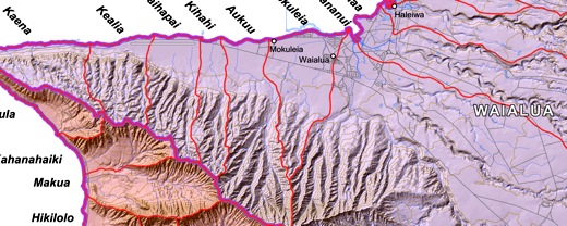
Image above: Detail of Oahu  traditional land divisions. Click to see whole island.

Available Downloads:
GoogleEarth file .KMZ (25MB) modified 2/7/14
24"x36" Plotfile .PDF (42MB) modified 2/7/14
Hi Rez Raster File .PNG (16MB) modified 2/7/14
Arcview GIS files .SHP ZIP (1.6MB) modified 2/7/14
Mokupuni O Kauai


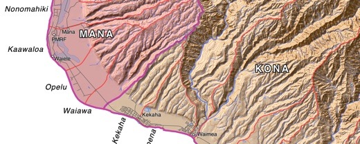
Image above: Detail of Kauai  traditional land divisions. Click to see whole island.

Available Downloads:
GoogleEarth file .KMZ (15MB) modified 5/6/14
24"x36" Plotfile .PDF (41MB) modified 5/6/14
Hi Rez Raster File .PNG (13MB) modified 5/6/14
Arcview GIS files .SHP ZIP (.4MB) modified 5/6/14
Mokupuni O Niihau


Image above: Detail of Niihau  traditional land divisions. Click to see whole island.

Available Downloads:
GoogleEarth file .KMZ (2MB) modified 11/18/10
24"x36" Plotfile .PDF (10MB) modified 8/3/10
Hi Rez Raster File .PNG (3MB) modified 11/1/11
Arcview GIS files .SHP ZIP (.4MB) modified 1/27/12

For background see:


• Modified 5 September 2014. Added S. P. Kalama maps of 1837and 1838.

IB Publisher's Note:

This article has been updated with links to high resolution images of S. P. Kalama's 1837 and 1838 maps of  Na Mokupuni O Hawaii Nei (the Hawaiian Islands). These were the only comprehensive maps known, that were created by a Hawaiian, to map the islands before the Great Mahele and the following introduction of private land ownership.

  Map above: Kalama Map of 1837. Click to enlarge to 5821 × 4067 pixels.

  Map above: Kalama Map of 1838. Click to enlarge to 13236 × 8698 pixels.

Note this map was printed in four sections. The Moku ares were colored by hand. The upper left quadrant; that included Oahu, Kauai, and Niihau; has only yellow and blue Moku colores and did not include green or red.

Pau


ISLAND BREATH
STAFF - EMAIL       

Juan Wilson: Publisher
Linda Pascatore: Editor


PARENT SITE
IslandBreath.org

NEWER ARTICLES 


2009 and on.

OLDER ARTICLES 
 

1993 to 2008.


MISSION

Island Breath is an online publication dedicated to people interested in the well being of the island of Kauai.  For us sustainability is crucial.

Kauai is often called the "Garden Island". It is lush and fruitful - yet threatened. If this island cannot be self-sustaining there is little hope for the rest of this world.

We define sustainability as:

• Using unrenewable resources no faster than they are recycled.

• Using renewable resources no faster than they are regrown.

• Restoring the variety and balance of living species.

• Enhancing the art and knowledge of human cultures.

Sustainability is not, however, a means for the continuing the status quo.


We have named our website “Island Breath” or “Breath of the Island” because in Hawaiian that phrase would be...

“Ea o Ka `Aina”

"The Spirit, Life and Sovereignty of the Land”

In fact, for many years the motto of Hawaii has been...

"Ua Mau Ke Ea O Ka `Aina I Ka Pono"

"Sovereinty of the Land
is Perpetuated in Righteousness"


There will be focus on...

Peace •
Environment • Justice • Regionalism • Activism • Culture

In the relation to...

Industrialism • Militarism • Corporatism • Collapse • Peak Oil • Climate Change