INDEX - PUBLIC ACCESS
www.islandbreath.org ID# 0501-11

SUBJECT: MOLOAA BAY RANCH CDUP PERMIT

SOURCE: JUAN WILSON juanwilson@mac.com

POSTED: 8 OCTOBER 2005 - 12:00pm HST

Sierra Club recommendations to DLNR


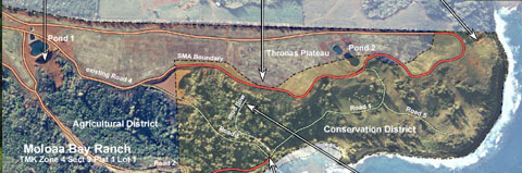
detail of Sierra Club map on Moloaa Bay Ranch CDUP recommendations. Click to download 2.7meg PDF

Editor's Note:

Attend the October 11th Planning Commission Public Hearing
Lihue Civic Center, Moikeha Building
Meeting Room 2A & 2B
4444 Rice Street, Lihue, Kauai, Hawaii

The following is a letter from the Kauai Group of the Hawaii Chapter of the Sierra Club to the Hawaii State Office of Environmental Quality Control concerning Moloaa Bay Ranch Conservation District Use Permit


This letter is in regards the Moloaa Bay Ranch (MBR) property on Kauai (ID TMK 4-4-9-11:001). The MBR proposes to do work on this land in the Conservation District and within the Special Management Area (SMA). This proposal includes grading, road “reclamation,” and landscape planting.

The has watched with alarm the work done by MBR on its property. Some of the work has been done without proper permits, including grading, clear cutting natural stands of trees, and road building. Some of this work has led to mud slides, ocean contamination, disfiguration of the landscape and restricted public access to areas of the ocean front historically used by hikers, fishermen and plant gatherers.

Much of the remedial work requested in this proposal is due to the previous work done by the applicant. Other aspects of the proposal appear to be preparation for a large scale development within the Conservation District that has not been shared with the public or the State and County agencies that would need to approve such work.

The reason many of us have chosen to live on Kauai is its spectacular natural beauty. In the past the mountains, fields and shorelines were much more accessible. Due to changes in use, increased privatization, risk management, security and other factors most people have little access to many places they once enjoyed.

The Kauai Sierra Club takes the position that land designated Conservation District should live up to its name and be “conserved.” Special care should be taken by private landowner (as well as responsible agencies) to ensure that the natural environment and public access to it is protected.

The Kauai Sierra Club recommends that that applicant not “beautify” nature and develop roads on steep embankments of the ranch, particularly within the Conservation District. Moreover, the Kauai Sierra Club believes that the unpermitted construction of Reservoir Ponds 1 & 2 are too close to the embankment of the Thronas Plateau and should be relocated mauka to insure that another disastrous failure is not repeated.

The following two pages detail some of our concerns regarding the CDUP proposal.

Public Access Recommendations for
Conservation District of Moloaa Bay Ranch

A) The general public has access rights along the Coastal Trail in the Moloaa area deeds that are crossed by the trail. The Moloaa Bay Ranch (MBR) owners will make an acknowledgment of this access right of the public across MBR land in a legal covenant attached to deed and recorded in the State Bureau of Conveyances.

B) Due to discrepancies between different shoreline boundary maps and the age of the most recent (1994) State Shoreline Certification, a new certified shoreline will be completed, and accepted by DLNR, prior to the commencement of any site work.

C) The Coastal Trail on MBR land will be surveyed and legally recorded by the DLNR, and a ten foot wide public right-of-way will be officially designated and recorded in the State Bureau of Conveyances. The course of this trail will take an easily passable route along the high ground of the land identified as Grant 10095 Section D. Part of the existing Coastal Trail may be mauka of Grant 10095 boundary and should be left in its present location if no passable route exists makai of the 10095 boundary.

D) The DLNR survey and recordation will document the Coastal Trail between Moloaa Beach and the northern boundary of MBR property.  MBR development documents will reflect this continuity of the Coastal Trail.
E) The recommendations of the archeological study commissioned by MBR will be incorporated as conditions of the permit to protect and preserve all sites that study identified.

F) MBR will agree that any man-made or vegetative barrier to the public (e.g. fence or artificially planted and irrigated vegetation). will be setback at least 40 feet mauka of the designated Coastal Trail right-of-way, the State certified shoreline and the northern shore of Moloaa Stream. No barriers shall be constructed by the MBR that obscures the panoramic views of Conservation District land mauka of the Coastal Trail. The design (or replacement) of any man-made or artificially planted and irrigated vegetation barrier will be subject to Planning Commission review and approval.

G) The DLNR will not permit “reclaiming” the segment of road between “Road 2" and “Road 3" as a restricted private road. That segment will be aligned with the Moloaa Hui Road and provide pubic parking and access to Moloaa Beach on the north of Moloaa Stream and be maintained by MBR.

H) The DLNR will not permit “reclaiming” the roads in the Conservation District descending from the upper Thronas Plateau to the lower portions of the property; namely portions of “Road 1", “Road 3" and “Road 5". A MBR Master Plan for development of Conservation District land should be submitted for review to the DLNR prior to any road or grading requests.

Environmental Recommendations for
Conservation District of Moloaa Bay Ranch


1) The 1999 construction of unpermitted pond/reservoirs at the embankment edge of the Thronas Plateau has led to engineering failures and will likely lead to further compromises to the environment. It is recommended that reservoir Pond #2 be decommissioned and re-engineered at a location further from the embankment located outside the Conservation District. 

2) There has been a history of unpermitted landscaping and construction in the SMA zone dating back to shortly after MBR acquired this property in 1998. Unpermitted work subsequently led to the 2002 erosion, ocean pollution and disfigurement of the landscape. 

 3) Any remedial work on Conservation District hillsides damaged by unpermitted tree cutting should be executed in small phased sections without adding soil or fertilizer.  Plantings should include appropriate naturally occurring species that will not require irrigation. No further grading or grubbing should be permitted within the Conservation District. 
 
4) A good deal of natural healing after the catastrophic erosion in 2002 has already occurred. This demonstrates that natural processes can do an efficient job of restoring the landscape.   

5) The development of roads with steep grades (over 5%) within the Conservation District should be discouraged. During rain they become highways for erosion and muddy runoff that finds its way into Moloaa Stream and onto the reefs of Moloaa Bay. No regrading should be permitted on hillsides within the Conservation District, particularly  between Road #3 and Road #4. 


SUBJECT: MOLOAA BAY RANCH SMA PERMIT

SOURCE: CAREN DIAMOND kaimanacd22@yahoo.com

POSTED: 1 OCTOBER 2005 - 7:45pm HST

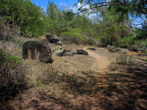
Planning Commission Field Trip to Moloa Bay Ranch


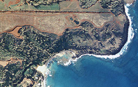
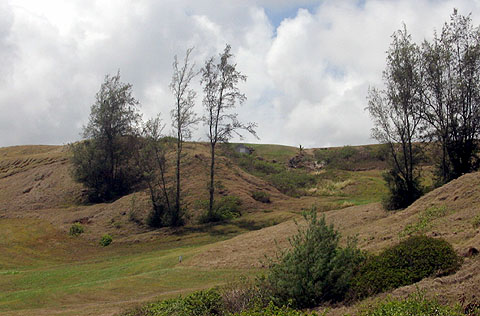
1999 aerial view of Moloaa Bay Ranch showing results of heavy tree cutting in Conservation District

If you plan to attend the Planning Commission Field trip to Moloaa Bay Ranch concerning permits in the Special Management Area Conservation District see the details below.

The Planning Commission will examine the site and at a later meeting decide on if and under what conditions they permit Thomas McClosky's plans for development on Moloaa Bay Ranch to go on Conservation District land.

COUNTY OF KAUAI PLANNING COMMISSION
SPECIAL MEETING/FIELD TRIP

October 5, 2005 8:30am
Lihue Civic Center, Moikeha Building
Meeting Room 2A & 2B
4444 Rice Street, Lihue, Kauai, Hawaii

A G E N D A

I. Call to Order:

II. Announcements:

III. Field Trip:

Recess and Continuation of Meeting for excursion to the Moloaa Bay Ranch property identified as TMK 4-9-11: por. 1 generally located on the northerly side of Moloaa Stream pertaining to Special Management Area Use Permit SMA (U)-2006-2 which proposes the construction of a perimeter fence, a retaining wall to protect an existing reservoir and pump station, the planting of new landscaping with associated irrigation system and grading associated with road reclamation, paving and repair. There will be no decision making by the Commission. The excursion will involve the following itinerary (adjustments subject to weather/site conditions-see attached map for general locations):

1. Meet at the northerly end of Moloaa Road near the Moloaa Stream
followed by a walk along the existing coastline trail to the northerly end of
TMK 4-9-11:por. 1 and return along the same route. -start approximately 9:30 a.m. or soon thereafter. *Please be aware of “No Parking” restrictions and private property along Moloaa Road and also please dress appropriately.

2. Drive along Hui Road for approximately .5 mile from its intersection with
Moloaa Road. -approximately 10:45 a.m. or soon thereafter

3. Meet at the intersection of Koolau Road and Larsen Beach Public Access
Road and drive to the Moloaa Bay Ranch property to view the project site.
-start approximately 11:00 a.m. or soon thereafter (Public comments pertaining to the site visit will be taken during item IV of the agenda, not during the field trip)

IV. Reconvene Meeting:
at Meeting Room 2A-2B, Lihue Civic Center, Moikeha Bldg,. Lihue to take public testimony pertaining to the site visit on SMA (U) 2006-2. -approximately 2:00 p.m. or soon thereafter.
(There will be no decision making by the Commission)

V. Adjournment


Note: there will a regularly scheduled meeting of the Planning Commission on October 11th at:

Lihue Civic Center, Moikeha Building
Meeting Room 2A & 2B
4444 Rice Street, Lihue, Kauai, Hawaii


SUBJECT: MOLOAA BAY RANCH SMA PERMIT

SOURCE: JUAN WILSON juanwilson@mac.com


POSTED: 29 SEPTEMBER 2005 - 10:30am HST

Sierra Club Recomendation to Planning Commission

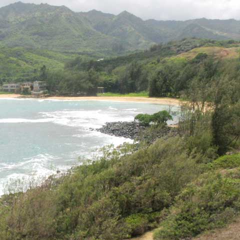
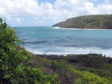
View of beach from Moloaa Bay Ranch looking south-west from Coastal Trail (center bottom)

The following is the final draft of the recommendation of the Kauai Sierra Club Executive Committee to the Kauai Planning Department concerning the upcoming Special Management Area Permit Request consideration for Moloaa Bay Ranch (MBR) , owned by Thomas McClosky. These recommendations are conditions that the Sierra Club is requesting the Planning Commission set on MBR to insure and enhance public access to the coastline and to preserve and protect the environment of the land:

Recommended conditions to be met in
Conservation District of Moloaa Bay Ranch
prior to requested SMA permit approval:

A) The general public has access rights along a Coastal Trail in all Moloaa area deeds that are crossed by the trail. The Moloaa Bay Ranch (MBR) owners will make an acknowledgment of this access right of the public across MBR land in a legal covenant attached to deed and recorded in the State Bureau of Conveyances.

B) Due to discrepancies between different shoreline boundary maps and the age of the most recent (1994) State Shoreline Certification, a new certified shoreline will be completed, and accepted by DLNR, prior to the commencement of any site work.

C) The Coastal Trail on MBR land will be surveyed and legally recorded by the DLNR, and a ten foot wide public right-of-way will be officially designated and recorded in the State Bureau of Conveyances. The course of this trail will take an easily passable route along the high ground of the land identified as Grant 10095 Section D. Part of the existing Coastal Trail may be mauka of Grant 10095 boundary and should be left in its present location if no passable route exists makai of the 10095 boundary.

D) The DLNR survey and recordation will document the Coastal Trail between Moloaa Beach and the northern boundary of MBR property.  MBR development documents will reflect this continuity of the Coastal Trail.

E) The recommendations of the archeological study commissioned by MBR will be incorporated as conditions of the permit to protect and preserve all sites that study identified.

F) MBR will agree that any man-made or vegetative barrier to the public (e.g. fence or artificially planted and irrigated vegetation). will be setback at least 40 feet mauka of the designated Coastal Trail right-of-way, the State certified shoreline and the northern shore of Moloaa Stream. No barriers shall be constructed by the MBR that obscures the panoramic views of Conservation District land mauka of the Coastal Trail. The design (or replacement) of any man-made or artificially planted and irrigated vegetation barrier will be subject to Planning Commission review and approval.

G) The Planning Commission will not permit “reclaiming” the segment of road between “Road 2" and “Road 3". That segment will be aligned with the Moloaa Hui Road and provide pubic parking and access to Moloaa Beach on the north of Moloaa Stream and be maintained by MBR.

H) The Planning Commission will not permit “reclaiming” the road designated “Road 5". The SMA permit for road improvements will not be approved until an MBR Master Plan for development of SMA Conservation District land is reviewed and approved by the Planning Commission.


The next scheduled meeting of the Planning Commission is October 11th. Bryan Mamaclay is the planner to the Planning Commission on this matter. To send testimony contact:

Bryan Mamaclay - re: Moloaa Bay Ranch
County of Kauai Planning Department
4444 Rice Street
Lihue HI 96766
phone: 808 241-6677


SUBJECT: MOLOAA BAY RANCH SMA PERMIT

SOURCE: JUAN WILSON juanwilson@mac.com


POSTED: 25 SEPTEMBER 2005 - 10:30am HST

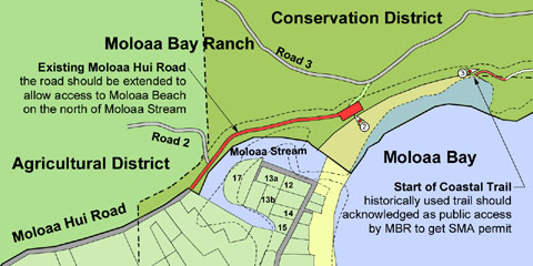
Request of Planning Commission for Access


Detail of proposal map showing new enhanced public access. For a 1.5meg PDF file click on here

Enhanced Access to Moloaa Bay Beach & Coastal Trail
by Juan Wilson on 25 September 2005

The following is a portion a proposal to the Sierra Club to request that the Kauai Planning Commisssion require the Moloaa Bay Ranch (MBR), owned by Thomas McClosky, to expand public access on his property as a condition for permitting reinforcement of a retaining wall to protect a previously unpermitted pump house and reservoir on Special Management Area land in a Conservation District. The proposal also denies MBR a permit to "reclaim" a road labeled "Road 5" until a Master Plan is submitted and approved by the Planning Commission.

This proposal is in response to comments and concerns voiced by the public and Palnning Commission members about the history of access in the Moloaa Beach area. It has been a history of ever increasing restriction.

I am hoping this proposal is adopted by the Sierra Club Executive Committee and that the Sierra Club recommend that the considtions in the proposal become part of the language of any future permit approval.For a PDF copy of this preliminary alternative proposal click on the map above. A text portion of the alternative plan to McClosky's request follows.

Recommended conditions to be met in
Conservation District of Moloaa Bay Ranch
prior to requested SMA permit approval

A) The general public has access rights along a Coastal Trail in all Moloaa area deeds that are crossed by the trail. The Moloaa Bay Ranch (MBR) owners must make an acknowledgment of this access right of the public across MBR land.

B) Due to discrepancies between different shoreline boundary maps and the age of the most recent (1994) State Shoreline Certification, a new certification must be completed prior to SMA approval.

C) Before SMA permit approval, the Coastal Trail on MBR land must be surveyed, and a ten foot wide public right-of-way should be officially designated by the DLNR. The course of this trail should take the high ground along the land identified as Grant 10095 Section D. Part of existing Coastal Trail may be mauka of Grant 10095 and should be left in its present location.

D) The DLNRtrail designation must document the Coastal Trail reaching Moloaa Beach and the northern boundary of MBR property. MBR development documents should reflect continuity of the Coastal Trail.

E) The MBR will be made responsible for the cost of clearing and maintenance of the Coastal Trail across its property and for providing the funding for appropriate public signage along the Coastal Trail.

F) Any barrier to the public (fence or planting) should be setback 40 feet from the Coastal Trail right-of-way, the State certified shoreline and the northern shore of Moloaa Stream. No barrier shall be constructed by the MBR that obscures the panoramic views of Conservation District land mauka or makai of the Coastal Trail. The design (or replacement) of any barrier will be subject to Planning Commission design review and approval.

G) The MBR will not “reclaim” the segment of road between “Road 2" and “Road 3". That segment will be aligned with the Moloaa Hui Road and provide pubic parking and access to Moloaa Beach on the north of Moloaa Stream and be maintained by MBR.

H) The MBR will not “reclaim” the road designated “Road 5". The SMA permit for road improvements will not be approved until a development Master Plan for SMA Conservation District land is reviewed and approved by the Planning Commission.


SUBJECT: MOLOAA BAY RANCH SMA PERMIT

SOURCE: JUAN WILSON juanwilson@mac.com

POSTED: 13 SEPTEMBERr 2005 - 12:30pm HST

Testimony at Planning Commission


view across Moloaa Bay from lower part of the Coastal Trail on Moloaa Bay Ranch property

by Juan Wilson on 13 September 2005

The following is my testimony to be presented today at the Kauai Planning Commission meeting concern ing a Special Management Area Permit Request by Moloaa Bay Ranch...

Aloha Commissioners;
The Special Management Area (SMA) Permit Request, now before the Planning Commission, by Moloaa Bay Ranch (MBR) for road building, fence construction and retaining wall reinforcement should be denied by the Planning Commission. There are many good reasons supporting the public interest for this position. The State designated Conservation District should be just that... CONSERVED.

Attached are 2 copies of a 24”x36” Site Plan prepared for the Kauai Sierra Club to review the current permit request by MBR. One copy is for the Commission the other for the Planning Department (att: Bryan Mamaclay). Also attached are 10 copies of an 11”x17” 45% reduction of the plan for your records. The Site Plan includes descriptions of the following 8 items needed to be resolved before this SMA permit request is granted.

1. The general public has access rights along the Coastal Trail in all local deeds that are crossed by the trail. The Maloaa Bay Ranch (MBR) owners must make an acknowledgment of this access right of the public.

2. The Coastal Trail on MBR land should be surveyed, and a ten foot wide public right-of-way should be officially designated by the Department of Land & Natural Resources (in place of former territorial Commissioners of Public Lands as mentioned in the deed).

3. As it is, current MBR documents do not show the Coastal Trail reaching Moloaa Beach for public access. They should. Due to discrepancies between different shoreline boundary maps and the age of the most recent (1994) State Shoreline Certification, a new certification should be completed prior to SMA approval.
4. Given the owner’s poor history as a developer, The MBR should be made to bear the cost of clearing and maintaining the Coastal Trail as it crosses MBR property and should be responsible for the the cost of providing appropriate signage along the trail for the public.

5. No fence should be built by the MBR that obscures the panoramic views of the Conservation District land mauka or makai of the Coastal Trail. No fence of any kind should be approved until DLNR approval of a surveyed course of the Coastal Trail.

6. The MBR has not shown sufficient evidence of roads to be “reclaimed” in the SMA area of the property. Road construction requested in the SMA should handled as new roadways and engineered appropriately.

7. Roads within the Conservation District should not be approved without identifying any and all future house lots or other developments within the SMA that are planned to be served by those roads.

8. Permission to build retaining walls to reinforce the reservoir and pump house, that were built without permits, should not be approved until the engineering and construction requirements of those structures meet pertaining code requirements and have been properly permitted.

The argument by the owner of MBR that the use of the Coastal Trail is limited only to immediate neighbors and “Native Hawaiians” is specious. Clearly, the history of the trail is that it was reserved as a public right of way during the transfer of public lands to private owners. There is an additional distinct reserved right, in the deed, for fishing and bathing, by adjacent property owners, along Moloaa Stream. This is obviously related only to the area near the stream on MBR land. The Coastal Trail is a separate reservation, for the public at large, seen in all area deeds.

Juan Wilson: Architect-Planner


SUBJECT: MOLOAA BAY RANCH SMA PERMIT

SOURCE: JUAN WILSON juanwilson@mac.com

POSTED: 9 SEPTEMBER 2005 - 10:30am HST

We don't want to be Pfluegered & Gubered again!


near the trailhead at Moloaa Bay Beach on public trail leading north along shore to Larson's Beach

Moloaa Bay Ranch Access Trail
Kauai Planning Commission Hearing
Tuesday, September 13, 2005, at 1:30pm
Lihue Civic Center

The Planning Commission will have a public hearing in room 2A-2B of the Moikeha Building at 4444 Rice Street in Lihue at the Civic Center on 13 September 2005 at 1:30pm.

Item 3 on the agenda is a Special Management Area Use Permit (SMA[U]-2006-2) for Moloaa Bay Ranch, owned by Thomas McCloskey (TMK 4-9-11:01) affecting approximately 64 acres. If you are concerned with public access, come to this meeting.

The recent history of work on Moloaa Bay Ranch has been dismal. Many shortcuts have been taken by this property owner resulting in regulatory violations and damage to the environment. This is part of a pattern of abuse of the public trust that has followed McCloskey from Aspen Colorado. Aspen Times wrote on December 6, 1999...

“Legal issues aside,McCloskey was widely perceived as breaking the sacred code of a mountain town - shutting off locals from historic access to the back country...”

Any SMA permit request from Mr. McCloskey should be closely scrutinized. He should not be given the benefit of the doubt on any statement he make regarding his support of the public’s interests. By public interest we’re not talking about supporting Little League teams and the Girl Scouts, we’re talking historic rights of access for the public to the land abd sea.


view up "reclaimed" Road 5 towards resevoir pump house (centered on top of ridge) from trail

On Kauai there has been an effort to maintain historic access paths for the public that connect sandy valley beaches around the prominent ridges that reach the ocean. Specifically, the deeds to Moloaa Bay Ranch include an access trail along a 10 foot wide right-of-way for the public. The trail connects Moloaa Beach to Larson’s Beach. This trail is used by fishermen, hikers and nature lovers. It is not for Thomas McCloskey to define who uses this trail. McCloskey has said...
“the trail is available to people who have the right to use it” and he has defined those people as adjacent property owners and native Hawaiians. Charles Lipscomb, ranch manager, has said

“the trail is being used by the public, but it is a private trail. We’re allowing use of a private trail.”

A primary worry to the public, and one that the Planning Commission should share, is that Mr. McCloskey’s intent is to deny access to the shoreline surrounding his property by denying access of the public to the access trail along the cliffs over the shorebreak. On his plans the trail is not shown connecting to Moloaa Beach. This should be corrected before any SMA permit is issued.

On Wednesday I hiked the trail with members of the Sierra Club from Moloaa Beach to the northern edge of the ranch property. We were directed to the location of the trailhead by a lifelong Hawaiian resident of Moloaa who has used the trail since the 1940’s.

On the hike it was obvious that the request to “reclaim” roads on the ranch is just another shortcut for McCloskey. Specifically, “Road 5” identified on the Planting Plan dated March 8, 2004 does not appear to have ever existed. There is no dirt road, path or the remains of a path that can be seen from the access trail. If there are to be such a road it should presented and engineered as new construction.
As we finished our hike back at Moloaa Beach, a ranch employee on an ATV "discovered" us. He parked his ATV blocking access to the trailhead behind us and radioed for instructions. Will this be the future of the trail under McCloskey's reign?
As I understand it, the SMA request by Mr. McCloskey includes a retaining wall in order to protect a reservoir and pump house that was built without permits. If true, the Planning Commission should deny such a request unless Moloaa Bay Ranch provides a significant benefit to the public.

the viewfrom the public trail towards Larson's Beach from the norther edge of Moloaa Bay Ranch

As a condition of the SMA use permit I feel the property owner should guarantee to the county that it will generously support the use of the public trail by all. This guarantee should include providing signs indicating the trail’s course and seasonal clearing and maintenance.

The residents of Kauai don't want to be "Pfluegered" and Gubered" by anyone, including Mr. McCloskey.


www.islandbreath.org

Pau