Hawaiian
Land Areas
SUBHEAD: Ahupuaa, Moku, Waihona and Life Zones of Hawaii Nei.
Updated Juan Wilson modified on 20 May 2018 for Island Breath -
(http://www.islandbreath.org/hawaiinei/hawaiinei.html)
Image above: Detail of Ka Mokupuni o Oahu showing Moku, Ahupuaa and Life Zones.
Note
that this group of maps is a new set that removes the solid color
tint that filled each Moku on previous maps. The new coloration is based on the "World Life Zone System" created by L. R. Holdridge with mapping produced by the Tropical Science Center, Geographic Information System Unit in San Jose, Costa Rica in July 2001 by J. Tosi, V. Watson, R. Bolanos and prepared by V. Jimenez.
Also the maps are now deliniating areas we are calling "waihona" which
we beleive are crucial water related resources in the Hawaiian Islands.
To read the introduction to this material see:
(http://islandbreath.blogspot.com/2016/05/introduction-to-hawaiian-land-areas.html)
The older Ahu Moku work can be found here: (http://www.islandbreath.org/mokupuni/mokupuni.html)
Modifications
to Kauai were uploaded 5/3/18. Files inlcuded were a .pdf plot file
(24"x36") and .png print file (4,316x4,060 pixels). New additional
information has been added of building footprints and many significant
mountain leak locations and names.
In addition, a correction to the Kauai Puna moku uploaded 5/18/18 now
shows the ahupuaa of Hulaia to include the Menehuni Fishpond.
This modification provides better access to the ocean for Hulaia.
Mokupuni
O Hawaii
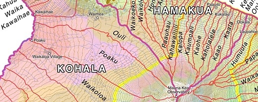
Image above: Detail of Hawaii traditional land divisions. Click to see whole island.
Available Downloads:
GoogleEarth file .KMZ (15 MB) updated 5/1/16
24"x36"
Plotfile .PDF (58 MB) updated 5/1/16
Hi Rez
Raster .PNG
(11 MB) upldated 5/1/16
ArcView GIS files .SHP ZIP (1 MB) uploaded 5/1/16
AutoCAD drafting files .DXF ZIP (917 kb) uploaded 5/1/16
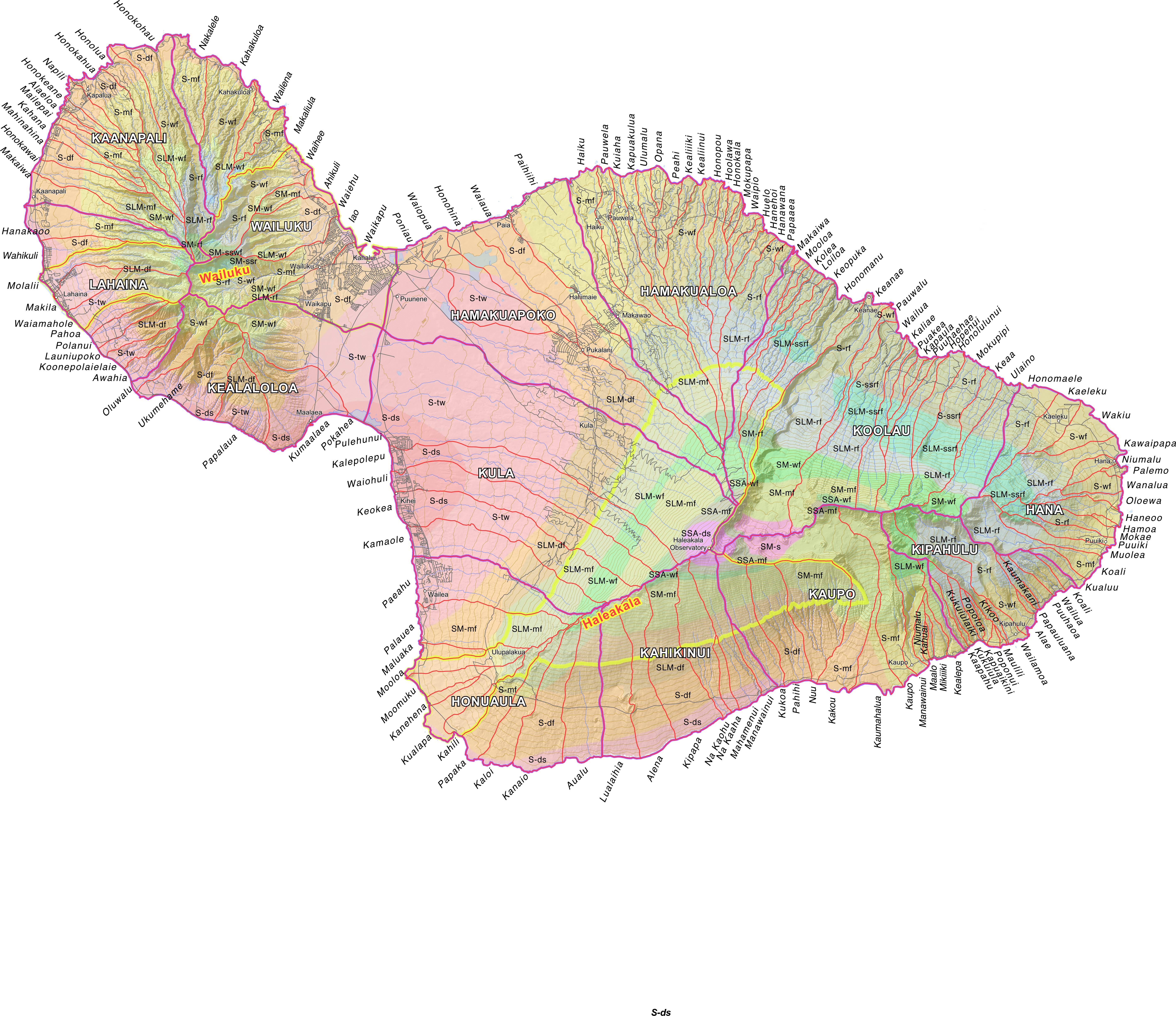
Mokupuni
O Maui
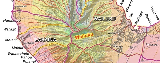
Image above: Detail of Maui
traditional land divisions.Click
to see whole island.
Available Downloads:
GoogleEarth file .KMZ (6.6 MB) uploaded 6/15/16
24"x36"
Plotfile .PDF (50 MB) uploaded 5/26/16
Hi Rez Raster
File .PNG (15 MB) uploaded 7/15/16
ArcView GIS files .SHP ZIP (418 kb) uploaded 7/15/16
AutoCAD drafting files .DXF ZIP (430 kb) uploaded 7/15/16
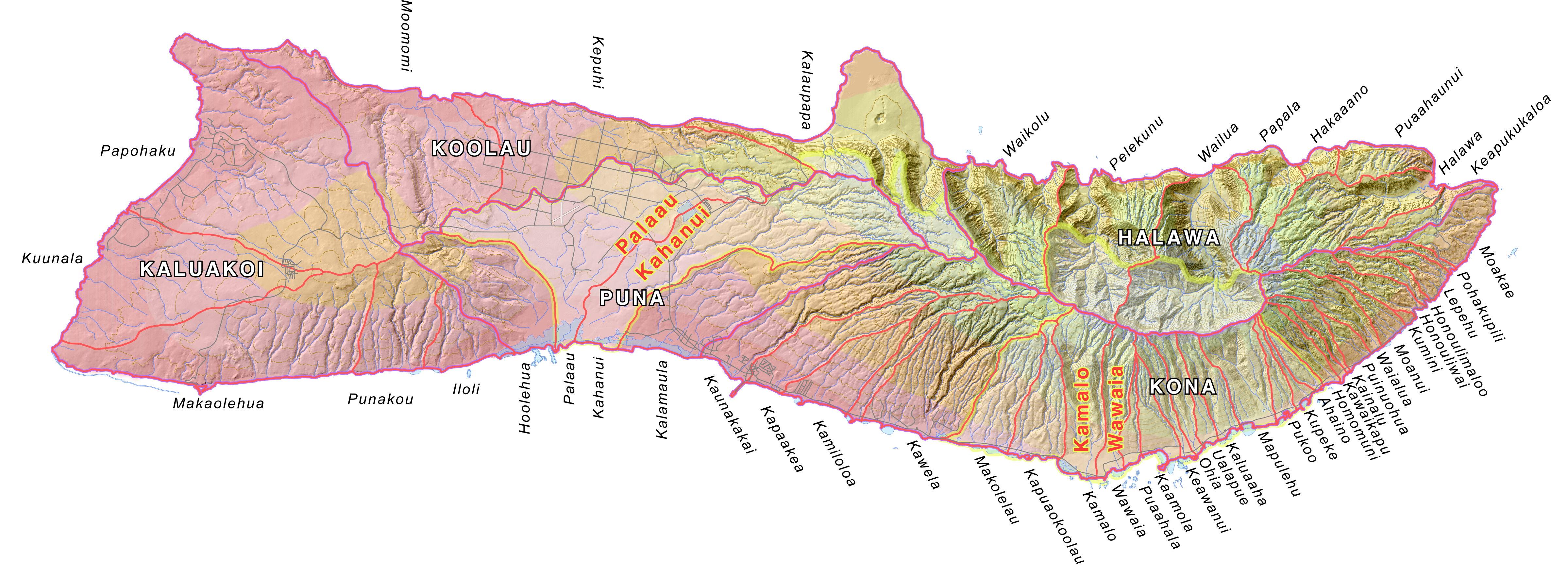
Mokupuni
O Molokai
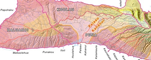
Image above: Detail of Molokai traditional land divisions. Click
to see whole island.
Available Downloads:
GoogleEarth file .KMZ (11 MB) uploaded 5/26/16
24"x36"
Plotfile .PDF (25 MB) uploaded 5/26/16
Hi Rez
Raster File .PNG
(7 MB) uploaded 5/26/16
ArcView
GIS
files .SHP
ZIP
(367 KB) uploaded 5/26/16
AutoCAD drafting files .DXF ZIP (158 KB) uploaded 10/3/17
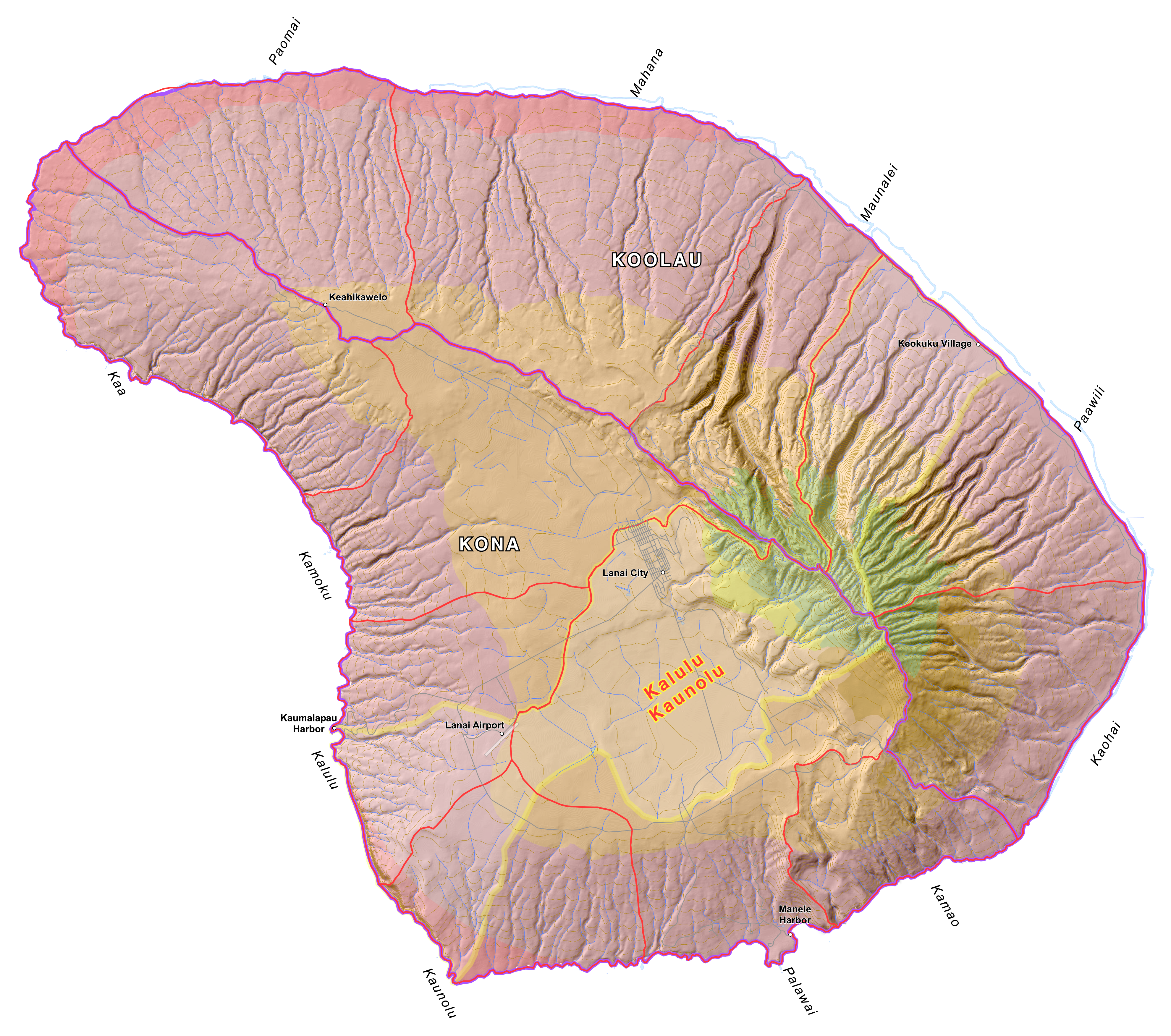
Mokupuni
O Lanai
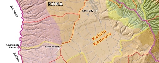
Image above: Detail of Lanai
traditional land divisions. Click
to see whole island.
Available Downloads:
GoogleEarth file .KMZ (7 MB) uploaded 5/1/16
24"x36"
Plotfile .PDF (30 MB) uploaded 5/1/16
Hi Rez
Raster File .PNG
(8.3 MB) uploaded 5/1/16
ArcView GIS files .SHP ZIP (123 KB) uploaded 5/1/16
AutoCAD drafting files .DXF ZIP (53 MB) uploaded 5/1/16
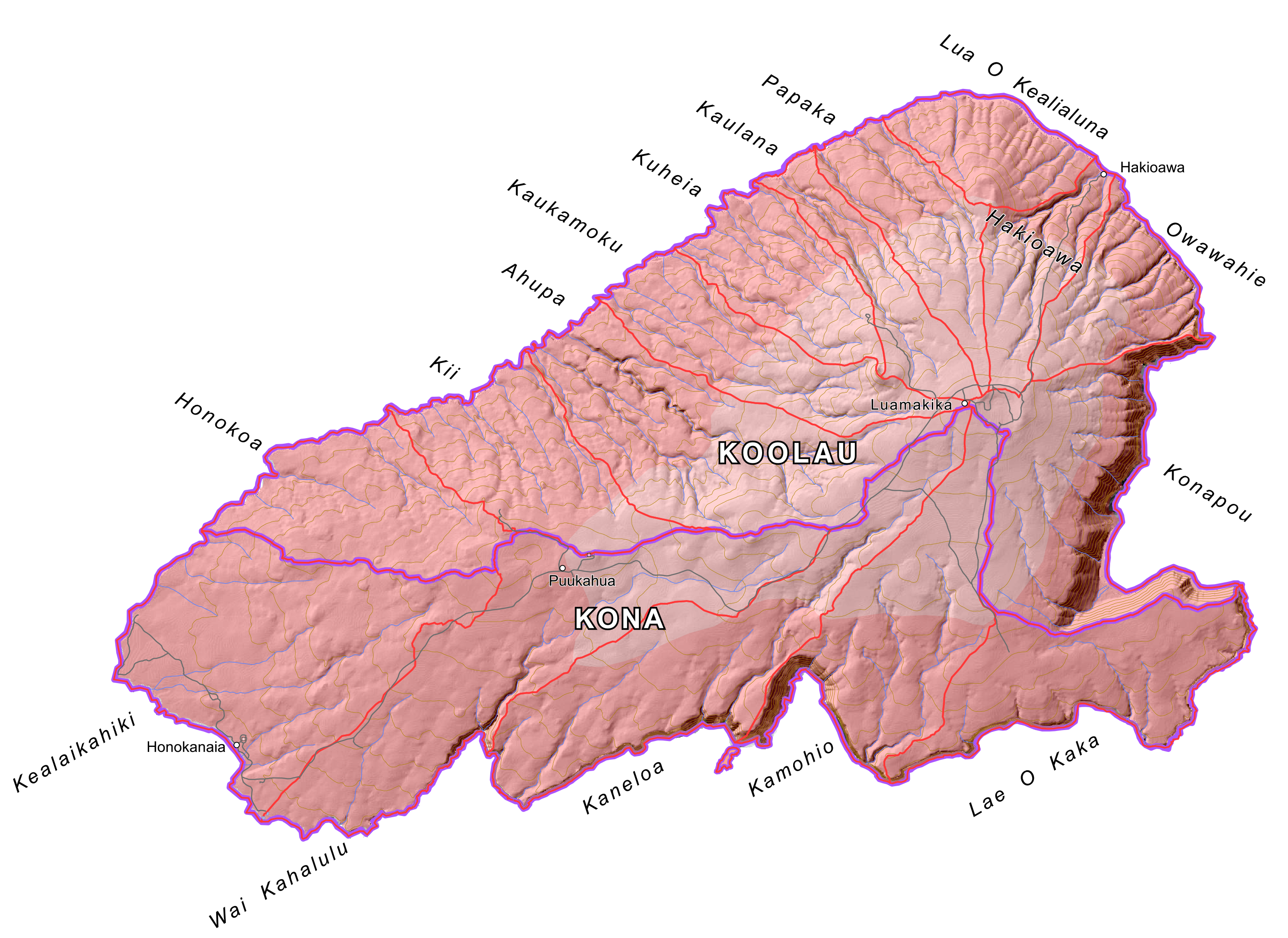
Mokupuni
O Kahoolawe
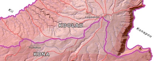
Image above: Detail of Kahoolawe
traditional land divisions. Click
to see whole island.
Available Downloads:
GoogleEarth file .KMZ (2 MB) uploaded 5/1/16
24"x36"
Plotfile .PDF (11 MB) uploaded 5/1/16
Hi
Rez Raster File .PNG
(3 MB) uploaded 5/1/16
ArcView GIS files .SHP ZIP (200 KB) uploaded 5/1/16
AutoCAD drafting files .DXF ZIP (71 KB) uploaded 5/1/16
Mokupuni
O Oahu
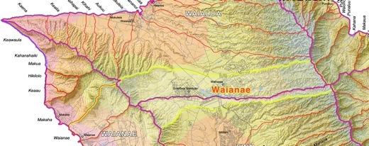
Image above: Detail of Oahu traditional land divisions. Click
to see whole island.
Available Downloads:
GoogleEarth file .KMZ (25 MB) uploaded 3/2/17
24"x36" Plotfile .PDF (42 MB) uploaded 3/14/17
Hi Rez Raster
File .PNG (15 MB) uploaded 3/14/17
ArcView GIS files .SHP ZIP (1.6 MB) uploaded 5/1/16
AutoCAD drafting files .DXF ZIP (723 KB) uploaded 5/1/16
Mokupuni
O Kauai
Image above: Detail of Kauai traditional land divisions. Click
to see whole island.
New Available Downloads:
GoogleEarth file .KMZ (15 MB) uploaded 5/19/18
24"x36"
Plotfile .PDF (44 MB) uploaded 5/19/18
Hi Rez
Raster File .PNG
(15 MB) uploaded 5/19/18
ArcView GIS files SHP .ZIP (319 KB) uploaded 5/19/18
AutoCAD files DXF .ZIP (2.7 MB) uploaded 5/19/18
Mokupuni
O Niihau
Image above: Detail of Niihau traditional land divisions. Click
to see whole island.
Available Downloads:
GoogleEarth file .KMZ (2 MB) uploaded 5/1/16
24"x36"
Plotfile .PDF (10 MB) uploaded 5/1/16
Hi Rez
Raster File .PNG
(3 MB) uploaded 5/1/16
ArcView GIS files .SHP ZIP (76 KB) uploaded 5/1/16
AutoCAD drafting files .DXF ZIP (59 KB) uploaded 5/1/16
WORK HISTORY
In 2007 Juan Wilson and Jonathan Jay began a
process to identify and map the traditional Hawaiian mokus and ahupuaa
on Kauai. We found the way water moves over the land and the effects it
has creating those places. We participated with the Aha Kiole
Committee, then lead by the late Jean Ileialoha Beniamina. It issued a
report in December 2008 locating and naming the traditional mokus and
ahupuaa on each Hawaiian island through interviews with kapuna.
In 2010 Juan Wilson contracted with the Western Pacific Fishery Council
(under NOAA) to map the moku and ahupuaa of the Hawaiian Islands for
the Aha Moku Council (now part of the Hawaii DLNR). The names and
boundaries of those areas on this map are founded on that effort that
was completed in June 2011. Since then we have made what we hope are
useful adjustments, corrections, additions and refinements to the
maps through 2015.
These maps are now being revised by Wilson & Jay to include the
World Life Zones as well as modifications based on factors such as
rainfall, changing use of land, population shifts, cultural change and
ecological modelling.
TOPOGRAPHY
Three dimesional geometry is made up of mostly "positive" and "negative"
surfaces. Hills and ridges are positively curved and valleys and
depressions are negatively curved. Islands are largely made up of
ridges that border valleys with streams that flow to the sea.
AHUPUAA
In
our nomenclature the “ahupuaa” refers to the land that makes a food
independent area for at least a group, village or community. These
ahupuaa consist of at least one stream watershed that reaches the
ocean. It may incorporate several streams. In a few cases two
separate ahupuaa join in a large stream or river just before entering
the ocean. One example is where the ahupuaa of Waimea and Makaweli meet
just upstream of where the Waimea River reaches the sea. An
ahupuaa is the specific place a Hawaiian from. Where they are “kamaaina” - "the fruit of that place".
Essencially, an
ahupuaa is a "negative surface" - as it is a depression between to
ridges (positiive surfaces) that lean in the direction towards the sea.
MOKU
We use the term “moku” to describe a group of contiguous ahupuaa that
make a bio-regional unit on an island. All islands have, for example, a
“kona” (leeward) and “koolau” (windward) moku. More than one island has
a “puna” district - a place of spring water; and more than one island
has a “pali” moku - north or northwestern facing cliffs. These
characteristics make the ahupuaa in general hotter, dryer and flatter
in the kona moku and cooler, wetter and steeper in the koolau moku.
A moku basically consist of several such "negative" valley surfaces that are joined along
common ridge lines.
SADDLES
However, there are places on these islands where two ridges and to
valleys interrsectr in surface that is both positively and negatively
shaped - like a horse's saddle. The largest example of such a surface
in the Hawaiian Islands is the ridge on the Big Island between Mauana
Loa and Muana Kea mountains. The resulting two massive
valley systems are Kohala Moku to the West and Hilo Moku to the East.
Connecting them is the Saddle Road that crosses the island.
Another
kind of understanding of these islands that we are just beginning yo
realize is appeared on many historic maps but not very consistantly or
with much expanation. These areas cross over and span several ahupuaa
and more than a part of one moku. These areas are clearly
identified and delineated by survey on the Big Island (see 1891
Government Survey of Kaohe and Humuula by C. J. Lyons) and Oahu (see
area of Waianae in 1881 Hawaiian Government Survey of Oahu by C. J.
Lyons). Reference is made to such an area on Maui as well (see Wailuku
area of 1885 Hawaiian Government Survey of Maui by W. D. Alexander).
WAIHONA
There
is spirital and other kinds of interpretations made of these areas. We
see another possibility that relates back to fresh water. This is not
related to how it flows down the sides of ridges and into valleys to
become streams and rivers that produce life and join the ocean. It is
related to where the water comes from to the islands. How the shapes of
the peaks catch the clouds and direct the resulting rain and where that
rain is stored under the surface of the island. We have named these
areas "Waihona".
In the online Hawaiian Dictionary (http://www.wehewehe.org/)
"Waihona" translates as "Depository, closet, cabinet, vault, file,
receptacle, savings, place for laying up things in safe-keeping".
Unlike the boundaries of of ahupuaa or moku - that follow ridge and
shorelines - the waihona boundaries sometimes follow contour lines
along a level elevation. This is most clearly
seen on the Big Island where Kahoe-Humuulu waihoina
boundary follows the treeline at
6,000' elevation around Muana Kea before following ridge lines down the
ocean on Hamakua coastline. On our current maps we are showing Waihona
on the Big Island, Maui and Oahu only. Their boundaries are yellow
lines.
Waihona areas names often are related significant ahupuaa within
them. On Oahu there is a community named Waianae within an
ahupuaa named Waianae within a moku named Waianae within a waihona
named Waianae. "Waianae" translates "Wai" - water plus "anae" - to
withhold for the future use. This may be the essence of Waihona. It is
where the fresh water is caught and stored on these islands.
Molokai and Kauai have remnants of such saddle shapes that have
collapsed or been greatly eroded. On Molokai this area is called Palaau
and extends into fresh water uprisings in the ocean on the southern
coast (see the 1897 Hawaiian Government Survey of Molokai by W. D.
Alexander) and on Kauai it is called Waimea and includes the Alakai
Swamp and the wetlands that once dominated the Mana plain. (see
Kauai Government Survey of 1878 by
W. D. Alexander).
USE & REPRODUCTION
The
resulting work produced files available to the public that include
GoogleEarth files, PDF plot files for producing 24"x36" maps, as well
as
high-resolution bitmap (PNG raster image) files and geographic
information system SHP files compatible
with Arcview and DXF files used by AutoCAD and CNC systems. On request
we will consider supplying Canvas GIS illustration files in CVX format that
are the source for much of this work.
After their first
report was finished and the maps were completed, the Aha Kiole Advisory
Committee became the Aha Moku
Council.
Links to those files, by individual islands, are available here (http://www.islandbreath.org/mokupuni/mokupuni.html). The
files can be used for non-commercial use by the public.
If you choose to use any of these files or publish them, please give credit to
the source "IslandBreath.org �2016". Please do no alter these files
without consultation and permission. If commercial use is desired, for
example selling printed maps, contact us for arrangements.
Juan Wilson
juan@islandbreath.org
(808) 335-0733
PO Box 949, Hanapepe, Hawaii, 96716
Jonathan Jay
jjkauai@gmail.com
(808) 212-7686
5956 Lokalani Road, Kapaa, Hawaii 96461
Note:
This
article has been updated with links to high resolution images of S. P.
Kalama's 1837 and 1838 maps of Na Mokupuni O Hawaii Nei (the
Hawaiian Islands). These were the only comprehensive maps known, that were created
by a Hawaiian, to map the islands before the Great Mahele and the
following introduction of private land ownership.
 Map above: Kalama Map of 1837. Click to enlarge to 5821 � 4067 pixels.
 Map above: Kalama Map of 1838. Click to enlarge to 13236 � 8698 pixels.
Note this map was printed in four sections. The Moku ares were colored
by hand. The upper left quadrant; that included Oahu, Kauai, and
Niihau; has only yellow and blue Moku colores and did not include green
or red.
Pau
|
|
|
|
ISLAND BREATH
STAFF
- EMAIL
Juan Wilson:
Publisher
Linda
Pascatore: Editor
PARENT SITE
IslandBreath.org
NEWER ARTICLES
MISSION
Island
Breath is an online publication dedicated to people interested in the
well being of the island of Kauai. For us sustainability is
crucial.
Kauai
is often called the "Garden Island". It is lush and fruitful - yet
threatened. If this island cannot be self-sustaining there is little
hope for the rest of this world.
We
define sustainability as:
• Using unrenewable resources no faster than they are recycled.
• Using renewable resources no faster than they are regrown.
• Restoring the variety and balance of living species.
• Enhancing the art and knowledge of human cultures.
Sustainability
is not, however, a means for the continuing the status quo.
We
have named our website “Island Breath” or “Breath of
the Island” because in Hawaiian that phrase would be...
“Ea
o Ka `Aina”
"The
Spirit, Life and Sovereignty of the Land”
In
fact, for many years the motto of Hawaii has been...
"Ua
Mau Ke Ea O Ka `Aina I Ka Pono"
"Sovereinty of the Land
is Perpetuated in Righteousness"
There
will be focus on...
Peace • Environment •
Justice •
Regionalism • Activism • Culture
In
the relation to...
Industrialism
• Militarism • Corporatism • Collapse • Peak Oil • Climate Change
|
|