SUBJECT: NEW SHAPE OF KAUAI
SOURCE: JUAN WILSON juanwilson@mac.com
POSTED: 5 MARCH 2006 - 9:30am HST
Computer mistake may shed light
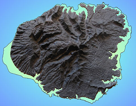
resin model of Kauai cut by CNC device from 3D computer model missing lower contours
Is
this the outline of Kauai's future shorebreak? Using the internet and his connections to people who fabricate, he recently was able to create a prototype model of Kauai about the size of a dinner plate. This was done using a numerical 3D computer model of the island a computer controlled (CNC) milling machine. The model was fabricated by a shop in Idaho that had no idea of what the shape of Kauai was. Tom had already determined that the model should have a vertical exaggeration of about three times its actual proportions. This is often done with 3D contour models of land, because the human eye does not see slight inclinations that are enough to gather a great river into a torrent. The world reduced to a hand-size is as smooth as a billiard ball. Typically, on less dramatic a landscape than Kauai, that exaggeration can be as great as ten-to-one. After a little trial and error Tom realized that Kauai looked best with less than a five-to-one height boost. The fabricator cut a plastic resin model of the island and then cast a solid bronze version of the island. It weighed about as much as a bowling ball and was beautiful, however, when it arrived here for examination there was something obviously wrong. The familiar border of the island was definitely wrong. I told Tom it was pretty obvious the CNC milling machine never got instructions to cut the lower contours of the island - that included the shoreline. It immediately occurred to me that as much as this would be a delay for Tom in his quest for a model of the current state of Kauai, it could be an opportunity to examine what Kauai might look like after he grip global warming has plunged the world into a rising sea of melting polar waters. Some scientists say if global warming melted Greenland, the Arctic and Antarctic icecaps the oceans could rise over ten meters (30 feet). The illustration above shows Kauai after such an inundation of the ocean. Note that all the Mana plain would be flooded extending the Napali Coast to Waimea. Some of the most populated areas of the island would be under water, including Waimea, Hanapepe, Poipu, and most of the residential areas between Hanamaulu and Anahola. All of the floor of Hanalei Valley would be under water. Much of the Kaumalii Highway and Kuhio Highway would be gone. One of the longest stretches intact would be connecting Kalaheo with the remains of Lihue. There would be the necessity of building quite a few new bridges connecting the dramatic escarpments flanking new bays, fjords and crossing steep canyons. It is likely that if my wife and I stay where we are in Hanapepe Valley we'll be running a floating marina over what used to be our backyard. At least we won't have chickens waking us up in the morning. to contact Tom
Teitge
|
