SOURCE: JUAN WILSON juanwilson@mac.com
POSTED: 26 May 2006 - 11:00pm
Public Speaks with one voice:
Leave Puolo Point in natural state!
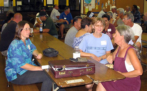
community members in the Eleele School cafeteria
meeting on Puolo Point development
plan
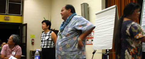
The meeting at Eleele School was well attended with over 50 members of the public present.The meeting was well facilitated by the planning consultant Nadine K Nakamura of NKN Project Planning. The meeting was scheduled by Kauai Mayor Baptiste to determine public interest in his idea of a Hanapepe Regional Park development. This relates to the mayor's discussions with the Hawaii Department of Transportation to have the County take on a lease for 65 acres of land between the Port Allen Airport and the shoreline on either side of Puolo Point. The leased area does not include Salt Pond Park, The Salt Pans area or the airport itself. At a later date discussions about the airport can occur with FAA. The meeting began with a brief presentation by the mayor of his plan for regional park in the Hanapepe Area that would link the existing recreational facilities along Puolo Road with the leased area and beyond to Salt Pond Beach Park. He said that the DOT might have plans to develop the area and that he hoped to get the lease to keep the Puolo Point area in local control and block such plans.
The mayor said, "Bottom line was that public indicated that it wanted recreation development in the General Plan of 2000." This in fact was not the case. Arius Hopman, a Hanapepe resident who has been active for years on the issues relating to Puolo Point, countered that the community asked that the area be designated Open Space and that is what is in the General Plan. After the mayor's remarks Nadine suggested the crowd break into several discussion groups, each with a large aerial map of the area. Each group was coordinated by a member of the mayor's staff to identify on the plans, with color coded markers, where there were opportunities for development and where there were areas that needed protection and conservation. After the small groups worked for about an hour each elected a representative to present the his/her group's concerns to the public at large. I personally believe the mayor expected that in this format the public would come up with a long wish list of projects that he could cherry pick for inclusion into his idea of a "regional park". This would be a formula for the development of roads, parking pavilions, rest areas, sports facilities, recreational activities like BMX and ATV use etc. If this is true the mayor must have been very disappointed. The presentation of group after group was echoed the theme "no development", "preservation and conservation", "leave it alone". There was concern for the environment, wetlands, bird sanctuaries, vehicle free walking paths, ancestral fishing rights, historical preservation and many other themes. None of them sounded to the mayor like "development". At several points during the following open discussion he said, "If you don't want to do anything with the land, the DOT won't let the County take over the lease." Members of the public countered that they did want to do something with the area "Protect it!'. They mayor seemed to be backing away from the lease idea at the end of the meeting if it meant he would be representing a public not interested in developing the area. It seemed obvious to many that the mayor had a secret agenda and was disappointed that the public was not in alignment with it.
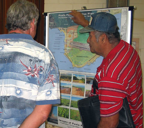
The Westside Watershed Council (WWC) had handouts and two presentation boards at the meeting that illustrated efforts to express the community's interest in the area. The WWC presentation was prepared by me, and I was pleased with how closely it matched the public's concerns. At the conclusion of the meeting Nadine Nukumura asked for members of the public to sign up for further planning initiatives by the community. She thought that using the WWC as a facilitating organization would be a good idea. The county was asked to post the results of the meeting in a summary form on the County's website and have printed summaries available to the the community. Kauai
County Mayor Bryan J. Baptiste email: mayor@kauai,gov Nadine
K Nakamura Westside
Watershed Council |
SOURCE: JUAN WILSON juanwilson@mac.com
Westside Watershed Council adopts plan
18 May 2006
- 10:00pm
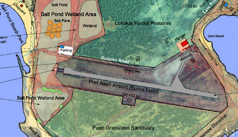
detail of Puolo Point Plan under consideration by the Westside
Watershed Council. Click on it for PDF
The Westside Watershed Council (WWC) has joined other community members in adopting a plan for Puolo Point that focuses on preservation, conservation, heritage and culture. For a view of the WWC version of the plan you can download a PDF file (3.7megs) here. A 24"x36" version of the plan will be on display at the meeting in the Eleele Elementary School cafeteria on May 25th at 6:00pm. |
SOURCE: JUAN WILSON juanwilson@mac.com
Puolo Point Meeting in Eleele!
18 May 2006
- 7:00am
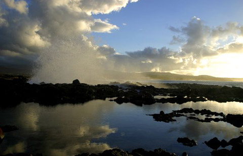
image of Puolo Point at dawn showing seawater pools used by infant fish
- by Arius Hopman
Will
this be another non-dialog meeting? The mayor has said, "We are starting the planning process for Salt Pond Regional Park" In fact, the
area of the park he has described is actually Puolo Point. What
has convinced the mayor that the area or residents need another
regional park? Restoration, Preservation & Conservation The mayor seems
bent on going the other way by inviting the public to In the Garden
Island the article announcing the meeting was titled... Anybody who
was attended a recent public meeting where the county (read mayor)
is seeking public "input" has had to endure endless "PowerPoint"
presentations. Besides the mayor the county parks administrator
will make a presentation. Usually these presentations have follow
up with the reading written questions that are filtered through
the mayor's handlers and not brought to the level of dialog. "There will also be time for questions and answers." I hope the mayor comes to this meeting with an open mind and seeking the voice of the people. I do not want to attend another meeting where his mind is made up and he does not want to hear our voices. |
see also
IslandBreath: Puolo Point 4
IslandBreath: Poulo Point 3
IslandBreath: Puolo Point 2
IslandBreath: Puolo Point 1
Pau