INDEX - MILITARY
www.islandbreath.org ID# 040414

SUBJECT: PMRF LAND REQUEST - PART FIVE

SOURCE: CAROL BAIN bain@kauai.net

POSTED: 10 JUNE 2004 - 8:00am HST

Hoike Fails to Deliver PMRF Hearing as Promised


area of shorebreak in front of beachside military housing (and rentals) now off limits to public


The presenter of this program, Linda Harmon, promoted the viewing of recorded BLNR hearings to no avail. Hoike only has 10 playback machines for all the PEG channels. They should have 24 hour playback capabilty for each channel, as Hoike receives $300,000 a year of state-mandated funds (derived from our cable fees) to do so. Though Hoike invested in an expensive "Tilt-a-Rack" playback system which arrived Nov. 2003 to do this, they cannot get it to work.

Our public access cable TV facilty is not meeting its mission to simply play back submitted programs in a timely manner. Consider writing a complaint to the Department of Commerce and Consumer Affairs. Ask DCCA to make Hoike fulfill its playback function.

Reach the Department of Commerce and Consumer Affairs Cable Television Division (DCCA-CATV)

E-mail:
cabletv@dcca.hawaii.gov <mailto:cabletv@dcca.hawaii.gov>

Phone:
Neighbor island residents may call using the following toll-free numbers:
Hawaii: 974-4000
Maui: 984-2400
Kauai: 274-3141
Molokai/Lanai:1-800-468-4644

Upon dialing the appropriate number for your island, you will be asked to enter the extension number. The DCCA telephone extension is 62620

Oahu residents only:
Phone (808) 586-2620

Mailing Address:
Director Mark Recktenwald
DCCA-CATV
P.O.Box 541
Honolulu, HI 96809


SUBJECT: PMRF LAND REQUEST - PART FIVE

SOURCE: LINDA HARMON harmonl001@hawaii.rr.com

POSTED: 5 JUNE 2004 - 9:00am HST

Hoike to Show Public Hearing on Land Grab


A Lance target missile launches from PMRF as part of Pacific Blitz. Click on image for more

The second and last  public hearing on the PMRF land grab of 5,500 acres of the Mana Plain was held by the Board of Land and Natural Resources (BLNR) last week, Monday May 24th.

The public testified and the BLNR decided.. The PMRF packed the meeting with employees of the base who were brought to the meeting in an air-conditioned bus and paid for the day to testify. The PMRF staff were front loaded on the speakers list. No matter. After the PMRF employees got there chance, the real public kept stepping up to the mike for 5 hours. The BLNR, ignoring the testimony of the public, gave the Navy control over the the the Mana Plainfor 25 years.

If you did not attend the hearing, you can see it on TV beginning Monday, June 7th.Carol Bain video taped the hearing until she ran out of tape (5 hours worth). She has provided the results in three parts to Hoike TV.

[Editor's Note: June 7th time has been corrected from 9:30am to 9:30pm]

The first of a three parts will be aired on Hoike, channel 53 this coming Monday, June 7th at 9:30pm. It runs about 2 hours. It will be re-aired on Tuesday, June 8th at 3:30pm.

The remaining two parts will be scheduled and aired subsequently.  When  Hoike knows, sometime during the next week, we will publish the times.

Editor's Note: The following is what the Navy brags about when talking to others about the PMRF


Pacific Missile Range Facility (PMRF) from www.GlobalSecurity.org

The Pacific Missile Range Facility (PMRF) is world's largest instrumented, multi-dimensional testing & training range. PMRF is the only range in the world where subsurface, surface, air and space vehicles can operate and be tracked simultaneously. This capability allows range users extraordinary flexibility in planning and conducting realistic multi-participant, multi-threat freeplay operations to train crews, evaluate tactics, and test weapon systems. Western Kauai is blessed with an ideal climate, averaging 361 sunny VFR flying days per years.

The mission of the Pacific Missile Range Facility(PMRF) is to facilitate Training, Tactics Development, and Test & Evaluations for air, surface, and sub-surface weapons systems and Advanced Technology Systems. PMRF provides the full spectrum of instrument range support, including; radar, underwater instrumentation, telemetry, electronic warfare, target remote command & control, communications, target launching facilities, data display, data processing and target/weapon launching and recovery facilities.

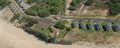
The headquarters and primary operation center of PMRF occupies approximately 1800 acres and is located on the western shore of the island of Kauai. The nearest town, Kekaha, is eight miles to the south and east. Supporting instrumentation sites at Makaha Ridge and Kokee Park overlook the vast ocean range areas to the west and north Kauai. The range encompasses 42,000 sq. miles of sea and air space and has minimal encroachments. The underwater tracking range extends over a 1000 sq. miles areas. PMRF features a state of the art instrumentation suite & communication network.

Lead range in the Pacific for Aegis Combat System Ship Qualification Training, PMRF puts new Aegis platforms through extensive testing & training prior to initial deployment. Collocated with the Sandia National Laboratory Kauai Test Facility, PMRF is the lead range for launching the Strategic Target System. No other range has the unencroached geographic expanse necessary to support wide area defense sensor and cooperative engagement capability testing.

Located in Hawaii on the western shores of the Island of Kauai, the PMRF range includes broad ocean areas to the north, south, and west with varying water depths from 400 to 2,500 fathoms. PMRF's relative isolation, ideal year-round tropical climate, and encroachment-free environment are significant factors in PMRF's excellent record for operation completions. PMRF's proximity to major Department of Defense installations and organizations, and to University of Hawaii ocean research facilities on Oahu, presents major cost and operational benefits to the range user. Transportation of project personnel, equipment, and materials is easily accommodated via commercial or military systems.

The area surrounding Kauai is divided into warning areas with W-186 and W-188 controlled by PMRF. The Fleet Area Control and Surveillance Facility (FACSFAC) controls W-187, 189, and 190. Space, air, and surface tracking are accomplished from PMRF precision-tracking radar sites at elevations of 75 ft., 1700 ft., and 3800 ft. These are supported by radar systems operated by agencies external to PMRF.

PMRF has extensive range instrumentation that is primarily used in the W-186 and W-188 areas, however capability exists to provide exercise/test support in-port, on-deck, in-transit and in other operating areas.

The Hawaiian Islands Complex is located in the waters adjacent to the islands of Oahu, Kauai, Maui, Hawaii, and Niihau. Instrumentation and equipment provided by PMRF are available to conduct in-port, on-deck, in-transit and range training exercises and tests in R-3101, W-186, W-188 and elsewhere. The complex is composed of the following instrumented areas and ranges:

Restricted Area 3101 (R-3101)
Barking Sands Tactical Underwater Range (BARSTUR)
Barking Sands Underwater Range Expansion (BSURE)
Hawaiian Area Tracking System (HATS)
Restricted Area (R-3107), Warning Area 187 (W-187), Kaula Rock
Warning Area 186 (W-186
Warning Area 188 (W-188)
Large Area Tracking Range (LATR)
Shipboard Electronic Systems Evaluation Facility (SESEF)

Non-instrumented warning areas and special operating areas associated with this complex are:
Warning Area 189 (W-189)
Warning Area 190 (W-190)
Warning Area 191 (W-191)
Warning Area 192 (W-192)
Warning Area 193 (W-193)
Warning Area 194 (W-194)
Warning Area 196 (W-196)
Echo Area
Uniform Area


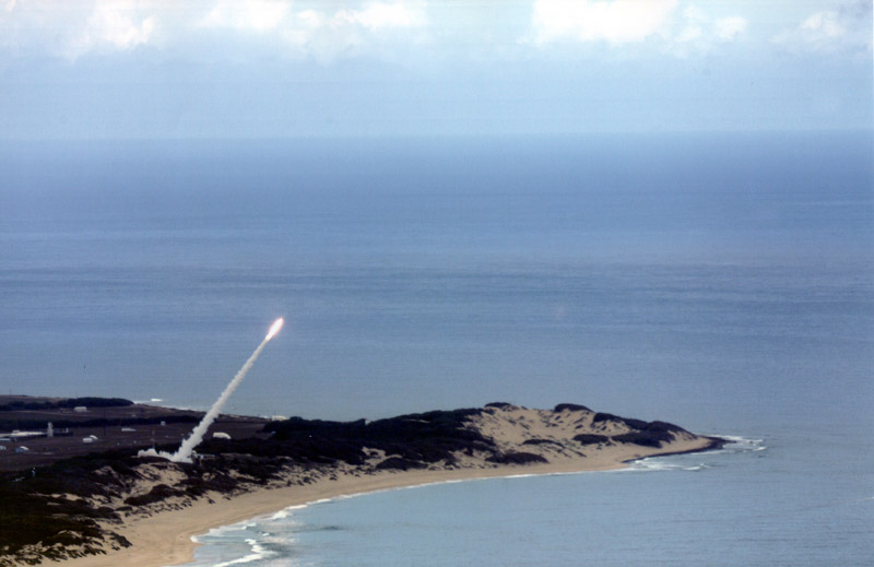
The Pacific Missile Range (PMRF) Facility's Large Area Tracking Range (LATR) system is an offshore, over-the-horizon, time space position information tracking system. The system supports tactical training at PMRF Barking Sands, Kauai; Wheeler Army Base, Oahu; and the 199th Fighter Wing at Hickam Air Force Base, Oahu. This upgrade uses newer technology that provides live control, in addition to debriefing capability. LATR integration gives the warfighter the ability to track and analyze open-ocean "war-at-sea" scenarios. It tests the combat readiness and battle tactics capabilities of the combat pilot. The first upgrade was installed at PMRF. The Navy has the option to upgrade the other LATR sites as well. The integration was pre-tested at the Oceana TACTS range, and then flown out to PMRF.

The PMRF Underwater Range consists of a 120-nmi2 area in the channel between Kauai and Niihau Islands in water depths from 200 to 1,000 fathoms, joining a 900-nmi2 area which extends into the open ocean north and west of Kauai, with depths from 1,000 to 2,500 fathoms. Hydrophones connected to the Underwater Data Processing system at Barking Sands yield 10-ft tracking accuracy throughout the Underwater Range. Underwater communications are provided through bottom-mounted transducers.

PMRF facilities on Oahu provide range services to ships and aircraft operating in the areas off Pearl Harbor, as well as ships in port and aircraft on the ramp. Operations support services are also provided in other remote training areas located on neighboring islands in the Hawaiian chain.

PMRF is capitalizing on new and affordable technologies to improve existing products, systems, and processes. Using a combinations of military and commercial communications pathways PMRF is expanding its inter connectivity with command staffs, test ranges, laboratories, and simulations facilities worldwide to enable real-time exchange or sharing of data.

PMRF measurement systems provide the capability to track, surveil, and collect telemetry from surface, airborne, and space vehicles. Underwater tracking is accomplished by a bottom mounted hydrophone array. Tracking and telemetry data is recorded, displayed in a variety of user formats, and may be electronically transferred in real time to customer data processing sites. The PMRF local area network utilizes fiber optic lines to ensure a clean, reliable information exchange. established connectivity with CONUS ranges, labs and facilities enables the sharing of data.

PMRF has developed an EW capability for use with all service requirements. Available ECM and threat emitter systems include land base, portable mobile, marine, and airborne systems, All combine to provide a multi-axis multi-threat presentation. PMRF EW assets are available to conduct in-port, on deck, in-transit, and on-range EW training and testing in designated areas throughout the state of Hawaii.

PMRF support the full spectrum of subsurface, surface, and airborne targets. Targets can be specially augmented with flares, emitters, and reflectors to affect their presentations. PMRF's C-12 aircraft, H-3 helicopters, Septars, and range boats all perform as cooperative mobile targets PMRF's helicopter, Septars, and range boats all perform as cooperative mobile targets. PMRF's helicopters and range boats perform target launch and recovery functions.

PMRF's Battle Management Interoperability Center (BMIC) contains the operational systems necessary to communicate and coordinate the complex activities involved in live fire testing and training. The BMIC enables a Joint task force Commander to access, display and disseminate tactical information (via OTCIXS) and Imagery (via STU III). The BMIC scenario generation system enables the use of synthetic data to stimulate C3 systems to enhance training realism.

The Pacific Missile Range Facility maintains and operates two contiguous underwater tracking ranges off the island of Kauai, Hawaii. The Barking Sands Tactical Underwater Range (BARSTUR) is located west of the island and consists of 42 bottom-mounted hydrophones which provide a coverage area of approximately 100 square nautical miles. The Barking Sands Underwater Range Expansion (BSURE) is located northwest of the island and consists of 18 hydrophones which provide a coverage area of 880 square nautical miles.

The PMRF has an acoustic system that uses the BARSTUR hydrophones for impact detection and scoring. The system is a post exercise, non-real-time approach that uses tape recorded hydrophone data. The data from several hydrophone channels are replayed on an oscillograph recorder. By visual inspection, the impact transient signals are distinguished from reverberation, extraneous noise, and non-impact related events. Time differences of arrival of the impact between pairs of hydrophones are measured manually and input to a computer program which calculates the impact location.

In response to technical requirements, PMRF listed mines, sonobuoys, air-launched torpedoes, vertical launch antisubmarine rockets (ASROC), and naval gunfire as the types of impacts. In addition, PMRF provides a number of other special applications for transient and continuous wave (CW) pulse type signals, where their existing detection and location system has been used in the past, but either a fully or semiautomated system would be more timely and productive. These include generating fixes on Dukane pingers; detecting and locating a torpedo end-of-run squib for torpedo recovery; B-52 bomb scoring; UQC and transponder surveys; tracking active sonobuoys; determining splash point and squib firing posits for a rocket assisted penetrator; and determining the depth of implosion for certain devices. The PMRF did not provide inputs on the area of coverage and accuracy; however, it is presumed that the required area is consistent with the present tracking coverage at BARSTUR which is approximately 100 square nautical miles. Similarly, it is presumed that the required accuracy is consistent with that attained with the NGSS which is ±5 to ±10 yards.

With the exception of naval gunfire which requires a fully automated, real-time system, PMRF would prefer a semiautomated, near real-time system for the other applications, because the acoustic impact signature may not always be known in some cases. Ideally, the signals from several hydrophones would be provided on a monitor where an analyst would select the impact transients to be used in the position solution. This desired approach is similar to the system presently in use at the AUTEC.

Range Control and the Operation Control Centers are in the Barking Sands operations area, one-half mile from the main gate. Tracking and surveillance radars, data processing, and the communication network hut are included in the operations area. A target support and red-label area is a mile north of the main gate, with the PMRF ordnance and launching area farther to the north. Airfield facilities in the main area of Barking Sands are capable of supporting up to and including C5-type cargo aircraft, tactical aircraft, and helicopters. Range support aircraft include six UH-3A helicopters which are used for surveillance, personnel transfer, logistics, target launch, and weapon/target recovery; and two RC-12F fixed-wing aircraft for range surveillance, electronic warfare, and logistics.

A benefit to range users is that range support from external agencies, including the following, is coordinated through the PMRF Program Manager.

The Naval Undersea Warfare Center (NUWC) maintains a facility at PMRF and a detachment at Waianae, Oahu, to provide Mk-30 underwater target services, exercise reconstruction, and range pinger installation services.

Sandia National Laboratories operates the Kauai Test Facility (KTF) for the Department of Energy and, through inter-Service Support Agreements (ISSA), provides PMRF with rocket launch services for target systems and upper atmosphere measurements. PMRF/KTF is recognized in the ABM Treaty as an authorized site from which launches of the STARS missile can be conducted. Environmental documentation is in place for a number of operational launch scenarios.

The Sandia Maui Haleakala Facility, linked to PMRF via leased circuits, provides telemetry receiving/recording, flight following, command control and flight termination systems for high-altitude/exoatmospheric launches from PMRF, and for high-altitude operations which traverse the Hawaiian Island chain.

The Air Force Maui Optical Station (AMOS), the Maui Optical Tracking and Identification Facility (MOTIF), and the Ground-based Electro-optical Deep Space Surveillance System (GEODSS), are located at the Maui Space Surveillance Site (MSSS) atop Mount Haleakala, provide a unique vantage point for observing sub-orbital vehicles.

The Hawaii Air National Guard provides O&M of the Hawaii Digital Microwave System (HDMS). The Hawaii Tracking Station, located at Kaena Point, Oahu, provides real-time telemetry data to PMRF via the HDMS. The 30th Range Squadron at Kaena Point provides metric and signature tracking data from their FPQ-14 radar via the HDMS.

Wheeler Network Communications Control (WNCC) is a major communications hub for PMRF. Voice and data signals are relayed through the HDMS to the WNCC from Mount Kaala, and are further distributed to other military and commercial communications networks. Hawaiian Telephone Company provides a dedicated T1 data link on the FTS2000 network from Barking Sands to AT&T on Oahu which provides CONUS interconnectivity to the Naval Warfare Assessment Division (NWAD), Corona, California. This link provides the capability for data reduction at NWAD and for nationwide video teleconferencing.

Since 1958, PMRF has performed over 6000 major training and T&E operations. Over the years customers have included all the services of the United States Military, many agencies of the Department of Energy & NASA, and many university & contractor research and development programs. United States allies such Australia, Japan, Canada, and the Republic of South Korea utilize PMRF for a variety of training and T&E operations.

For almost every aspect of Hawaiian life, there is a legend to explain the subject, but there is not always an explanation of the legend itself. Some have to be taken on faith. So it is with the Legend of Barking Sands. At a time long ago, an old Hawaiian fisherman lived in a hut near the beach with his nine dogs. During his fishing trips he would tie his dogs to stakes in the sand, three to each of three stakes. He would then get into his canoe and go fishing.

One day while he was at sea and the dogs were tied as usual, he was caught in a very bad storm. For hours he battled the heavy seas until he was finally able to return to land. He was so exhausted that he crawled into his hut, forgetting to untie the dogs. When he awoke the next morning and went outside, the dogs were nowhere in sight. All he saw were three small mounds of sand where the dogs had been tied. As he stepped on one of the mounds, he heard a low bark. Another step brought another bark, still he couldn't find the dogs. Believing the dogs had been buried in the sand because of the storm, the fisherman began to dig. As each shovelful was removed, more sand took its place. He finally gave up, and every day after that when he crossed the beach he could hear the low barking. The dogs were never found and to this day the sands of Mana have been known as the Barking Sands. After a time, the old fisherman died, some say from a broken heart for losing his dogs. Time passed, and in 1921, the land area known as the Barking Sands was acquired by the Kekaha Sugar Company from the Knudsen family. On occasion private planes would land and take off from the grassy field used for pasture.

In 1932, an Australian named Kingsford Smith made a historic flight from Barking Sands to Australia in a Ford Trimotor. Local people assisted him by clearing the runway area, filling holes, and marking the runway with flags at 1,000-foot intervals and whitewash at 500-foot intervals. The Kekaha Sugar Company brought fuel for his plane in barrels.

In 1940, the U.S. Army acquired 549 acres of land, including the grass landing field by Executive Order of the Territory Governor, Charles Hite. The Installation became known as "Mana Airport," and the Army paved the runway and made other building improvements. The only money involved in the transfer was $1,000 for administrative expenses.

In June 1941, additional acreage was transferred to the Army bringing the total land area to 2,058 acres. Hawaiian Airlines used the field for passenger stops, and Pan American Airlines made occasional landings at the field until Lihue Airport was completed in 1949. Barking Sands experienced very heavy military traffic during World War II, and a series of land transfers and easements caused continual changes in the total real estate assigned to the installation. Many name changes also followed: Mana Airport, Mana Airfield Military Reservation, Barking Sands Military Reservation, Kekaha Military Reservation, Barking Sands Airfield, Bonham Airfield, Bonham Air Force Base, Bonham Air Base, and Auxiliary Landing Field (ALF) Bonham.

In 1948, the Air Force Chief of Staff declared that Barking Sands Military Reservation was of no further use and that action would be taken to declare the base excess, with the concurrence of the U.S. Army Corps of Engineers. The Department of Air Force disapproved the recommendations and action was taken to acquire an additional 200 acres adjacent to Barking Sands, and in 1954 the name of the base was officially changed to Bonham Air Force Base.

The Navy's introduction to Barking Sands (Bonham AFB), was in 1956 when the Air Force granted a five year revocable joint utilization license to use 37 acres for Regulus I operations. Two years later, in November 1958, the Pacific Missile Range Facility was formally established with a PMR Representative Office at Kaneohe MCAS on Oahu. Meanwhile, the Navy was becoming the principal user of Bonham AFB, later called ALF Bonham, and formal negotiations began to transfer the base to the Navy. In 1962, the Pacific Missile Range Facility, Hawaiian Area was officially commissioned under a Commanding Officer. In 1963 a detachment was established at Johnston Atoll.

In 1964, negotiations were completed, and ALF Bonham officially transferred 1,885 acres of Barking Sands to the Navy. In 1966, Barking Sands was transferred within the Navy to the Commanding Officer, Pacific Missile Range, and renamed, "Pacific Missile Range Facility, Barking Sands." By this time, PMR had established a chain of stations throughout the Pacific. Besides Barking Sands and Kokee, several downrange stations under PMR included South Point, Hawaii; Midway Island; Wake Island, Eniwetok Atoll; Tern Island; Christmas Island; Canton Island; and the recovery ships, USNS Longview and USNS Sunnyvale.

In 1967, the Barking Sands Tactical Underwater Range (BARSTUR), and the Makaha Ridge Instrumentation Site, were completed. In 1968, the Command Headquarters, Pacific Missile Range Facility, Hawaiian Area was established at Barking Sands.

Facility improvements and expansions followed through 1974, and due to changing requirements and for more effective management and support, most of the "downrange" facilities were closed or transferred.

Kauai is pronounced ka-WAH-ee with the accent on the "wai" and a glottal break between the last two syllables (as in Ha'wai'i). A general translation of the word Kauai is "time of plenty" or "fruitful season." Know as the Garden Island, Kauai is famous for its flowering shrubs, vines and trees that grace the countryside year round with a beautiful background of every shade of green imaginable. Mount Waialeale, "Rippling Water," rising to 5,170 feet at Kawaikini Peak in the very center of the island, is the wettest spot on earth with 465 inches of annual rainfall, and is the source of Hawaii's only navigable rivers.

The beautiful Mount Waialeale also inspired the island's ancient name, "Kauai-a-mamo-ka-lani-po" which means "The fountainhead of many waters from on high and bubbling up from below." Kauai is also a land of contrasts with the startling rocky grandeur of Waimea Canyon, the virgin purity of Killable Valley, where wild cattle, goats, pigs and deer graze, the sunny desert warmth of the west side, and on the north shore, beautiful Lumahai Beach, known to many as Bali Hai in the movie "South Pacific." Geologically, Kauai is believed to be the oldest of the inhabited Hawaiian Islands, being the first of a chain of volcanic mountains to erupt from the sea and the first to become extinct. Historically, it is also the oldest of the group. Archaeological findings indicate that Kauai was probably inhabited over 1,000 years before Captain Cook's landing in Waimea on January 19, 1778. Kauai is the northernmost of the inhabited islands that make up the state of Hawaii, and is located 95 miles northwest of Oahu. It is roughly circular in shape, with a diameter of 32 miles and and area of 55 square miles. Kauai of today is a modern community with a population of approximately 55,000. Kauai's major industries are agriculture and tourism. The island produces one third of Hawaii's sugar crop. Much of the processing is mechanized, but the island's sugar plantations still employ many island residents. Cattle roam several large ranges and numerous smaller ones. Hogs and chickens are raised and marketed.

On Kauai, as in all of Hawaii, the tourism industry is increasing rapidly. Four major resort areas with their corresponding hotels, shops, restaurants and recreational facilities employ many island residents. Hawaii's cost of living is higher than that of most mainland areas, especially for housing and food. Some food items may be cheaper than on the mainland, but for the most part, transportation costs from the west coast represent the major cost difference. A new world of eating awaits you in Hawaii, inspired by the mixed ethnic background of the residents, Filipino, Portuguese, Japanese, Chinese and Hawaiian dishes are common. Most vegetable and fruits can be grown here with relative ease. Garden enthusiasts thus have an excellent opportunity to shrink their grocery bills considerably. Mangoes, papaya, bananas, plums, guavas, lilikoi (passion fruit), coconuts and other fruits grown wild on the island, providing an additional no-cost food source and many delightful new tastes.

The Legend of Barking Sands; There was an old Hawaiian fisherman who lived in a hut near the beach with his nine dogs. During his fishing trips he would tie his dogs to stakes in the sand, three to each of three stakes. He would then get into his canoe and go fishing. One day while he was at sea and the dogs were tied as usual, he was caught in a very bad storm. For hours he battled the heavy seas until he was finally able to return to land. He was so exhausted that he crawled to his hut, forgetting to untie his dogs. When he awoke the next morning and went outside, the dogs were nowhere in sight. All he saw were three small mounds of sand where the dogs had been tied. As he stepped on one of the mounds, he heard a low bark. Another step brought another bark, Still he couldn't find the dogs. Believing the dogs had been buried in the sand because of the storm the day before, the fisherman began to dig. As each shovel full was removed, more sand took its place. He finally gave up, and every day after that when he crossed the beach he could hear the low barking. The dogs were never found, and to this day the sands of Mana have been know as Barking Sands. The scientific explanation of this phenomenon is that the grains of Mana sand are tinny, hollow spheres. When rubbed together, the give off a popping sound similar to the barking of dogs. This only occurs when the sand is very dry. Wet sand gives off almost no sound.


SUBJECT: PMRF LAND REQUEST - PART FIVE

SOURCE: JUAN WILSON juanwilson@mac.com

POSTED: 25 MAY 2004 - 9:00am HST

Kauai: The Death Star


Death Rays. What was once science fiction is about to corrupt Kauai with greed and death

Welcome to Ground Zero!

On May 24th the west side of Hawaii State Department of Land & Natural Resources gave up its responsibility as stewards of the land, and gave control of the Mana Plain up to the military. The only request that they denied the Navy was the "in perpetuity" (forever) clause built into the agreement. Those of us that live as long as 2029 will be able to revisit this issue after 25 years of military development. Check out today's Garden Island News for more.

In case you are interested in what the Navy and the corporations (that are the real jackpot winners) will be up to I have this ad advice... Don't poke around too much. It's all about top secret deathrays and world dominion. Check this out from  ConspiracyLinks.com, TerrorAnalysis.com, ATSNN.com and BelowTopSecret.com


LASER WEAPON TECHNOLOGY AND THE STAR WARS PROGRAM
If a nuclear attack were launched on America, it could involve hundreds of missiles carrying thousands of warheads, each traveling at up to 4 miles a second towards targets they would reach within 30 minutes of launch. To protect themselves, the US have therefore developed their Strategic Defense Initiative (SDI) or 'Star Wars' program.

A major part of this program is to develop lasers that will shoot down enemy missiles within five minutes of launch. If it was left any later than this, then defense becomes much more difficult because the missile releases up to ten separate warheads and many decoys, greatly increasing the number of targets that have to be hit.
Lasers destroy their targets by directing onto them an intense beam of energy which travels at the speed of light - 186,000 miles a second. The simplest method of destruction is to focus a beam of infrared radiation on a missile so that it burns a hole in the rocket casing, causing fuel to escape so stopping the missile from reaching orbit. Another possibility is directing the beam to disrupt the rocket's electronic guidance system.

The US are developing a chemical laser in which hydrogen and fluorine react together to form hydrogen fluoride, which is a corrosive gas or liquid which can be made to release a powerful burst of infrared radiation. The laser is focused and aimed by prisms and mirrors. A chemical laser of sufficient power, at least 25 megawatts, could destroy a missile almost 2,000 miles away.

The lasers would attack their targets from battle stations in space, a few hundred miles above the Earth. However, a total of about 100 stations would really be needed to give the US the possibility of complete protection, and getting that many in space would dwarf any previous space project.

Just the hydrogen fluoride needed to fuel the lasers would weigh about 2000 tons! Think of the costs for that kind of payload. How would such a project be funded? A possible alternative to that might be to base the lasers on land. The difficulty then though is that the atmosphere would disperse the laser beam, making it impossible to focus on the missile's skin. Putting the lasers on top of high mountains would reduce distortion, obviously because their would be less atmosphere to penetrate. Advanced optical techniques designed to counteract the dispersive effect of the atmosphere may also help.

Even so, no more than a tenth of the power of the laser could be expected to reach the target, which means that the lasers fired from Earth would need to be very powerful. They would probably need to have the power of around 400 megawatts each. This is the equivalent electricity consumption of a medium-sized city, and 1000 times more powerful than any laser known to exist today.

Mirrors would have to keep the lasers locked onto the missile for several seconds before it would be destroyed. Even if this were achieved, the enemy could probably still defeat the laser by putting a heat shield around the missile or by making it spin so that the beam could not be focused on the same spot long enough to burn a hole.

The Star Wars program has also been developing lasers which produce X-rays rather than a beam of light. These X-rays are produced in a single pulse rather than a continuous beam (a pulse laser). The source of the X-rays is a small nuclear explosion. When the pulse of X-rays hits the enemy missile they are absorbed by it's skin, vaporizing it and blowing the missile apart. Because X-rays are rapidly absorbed by the atmosphere they would also have to be fired from space when both the laser, and the missile it was attacking, had risen above the atmosphere. This is at least 50 miles above the Earth.

The idea is not to station the lasers permanently in space, but to launch them only when satellite observations show that an enemy attack is already under way. The X-ray lasers would be launched from submarines, and would then be quickly boosted into orbit where they would be aimed and fired accordingly and automatically.


As I understand it, this laser technology will be developed and tested at the PMRF beginning in a project that will run 2006-2008; The Directed Energy Project. This technology produces so much energy through the lasing devices that they are destroyed in there use. One time firing for each "deathray". THis raises the question of what kind of waste products and hazards will be created with each weapon firing. Where do the corrosive chemicals and gases go when the weapon is obliterated?

The forces of destruction have won a significant round... and Kauai will suffer. Let us hope those that are behind it will be brought to the light. Bush = Death!


Well, at least your children can have jobs building and operating this equipment during WW3

The PMRF is quickly becoming the most important military target in Hawaii. It "secret" command and control capability and remote sensing technology is within range of Korean and Chinese nuclear missiles. The PMRF becoming a higher profile target because of it's "defensive" military potential. If the US was to attempt a pre-emptive attack on its "enemies" it would need the assurance that an enemy with nuclear weapons could be countered. That is one reason we need the deathray be developed at the PMRF. To stop an effective counter attack with the ability to shoot rockets and satellites out of the atmosphere or space. Could that be why we abrogated the ABM treaty.

As a kapuna (priest) said at a break in the hearing, maybe we should all start praying to our akua (god), so that in a few years another ino (storm) comes to scour the Mana Plain clean of GMO crops and US strategic weaponry. That way the the bones and souls of the kanaka maloi (native people) of Nohili can rest in peace. They certainly are defiled now.


SUBJECT: PMRF LAND REQUEST - PART FIVE

SOURCE: BILL YOUNG editor@thekauai.com

POSTED: 23 MAY 2004 - 3:00pm HST

The Fate of the West Side is at hand

PMRF Checkpoint "K" near the Kekaha Sugarmill? Not quite yet., it's Iraq & Kauai joined with PhotoShop

TOMORROW. A 9 A.M. MEETING MAY DECIDE FATE OF WEST SIDE
Hundreds may attend to testify against PMRF control of ag lands at Veteran's Memorial Center.
You may be disappointed to read the May 23 Guest Viewpoint by Rear Admiral Barry McCullough, U.S. Navy.

But Kaua`i can be proud of council person Yukimura's thorough response in Mr. Finnegan's article on the same subject.

The rear admiral's letter was calculated, and tried to give an explanation of the Navy's stance on this great issue that could affect the west side of Kaua`i in perpetuity.

To say that "Most have welcomed it..." (the proposal to give PRMF control over thousands of additional acres of ag land) is a fantasy. "...rightly seeing it as necessary to conduct military research in an isolated area..."

The fantasy continues.

Kauai's isolation was once the reason why Kaua`i was never conquered.

Now, isolation is the military's excuse to sacrifice Kaua`i because it sees our island as a safer place to conduct dangerous, often damaging "military research" than other less-isolated places. (GMO companies use the same reasoning). Why does its isolation make Kaua`i a better place than others? Because of the consequences if anything goes wrong and because as the base expands, we become a more vital target.

The Rear admiral should be happy that our patriotism and patience have allowed PMRF to remain at all.

Kaua`i has already given more than her fair share.


Thank you for lengthening the number of hours of beach access you now permit in an area to which the Navy's promise NEVER to restrict access (unnecessarily closed for over two years) was one of our original conditions for approval of PMRF (it's in the lease).

Your revealing admission that "security requirements in our post 9/11 world simply won't permit it" (greater access to our public beaches and fishing) was harsh and hurtful. But thank you. You've FINALLY clearly stated that you will never grant the access to the beaches Kaua`i never gave you the permission to close.

Your mission is not "vital to our nation's security." Kaua`i is useful to you. It's convenient for you. That's nice, but please don't use that old argument. The U.S. is in control of hundreds of other remote places. The Navy can expand on Diego Garcia island.

Your mission is not vital to Kauai's economy either.

The amount of money Kaua`i is losing in land it leases to you for $1 an acre is as great as the amount you and your jobs contribute to our economy. A marathon event could bring as much in a weekend as the additional income the base brings in a year.

Who is gullible enough to believe the Rear admiral's threat that the next time the Board meets, "it might not be from the Navy. It might be from a developer?"

Even given the terrible choice between two evils, the developer might be the lesser one.
But in this case, rest assured "Rear admiral" (?), Kaua`i will accept neither.

Don't worry. The Land Board will act to preserve this area for agriculture, but not under the Navy's control.

300 Kauaians vehemently protested against this additional control in November, and at Monday morning's BLNR meeting, please count how many are "welcoming it."

Just what can the Navy promise? As was clear at the county council meeting on this issue, the Navy cannot even promise it will NEVER ask for greater control over that area. It could only admit, "We have no plans at this time." Like it had no plans to close beaches.

Personally, "the next time the Board meets" (was the Rear admiral admitting the possibility that the proposal would be refused?), I am looking forward to testifying in favor of an agricultural development for native Hawaiians, local low-income farmers, and GMO-free farmers. We have already sacrificed far too much for the U.S. military.

Thank heaven a council member has stood up, WITH the people of Kaua`i to object to the set-aside.
Trust Kauaians to take care of our own agricultural land.


Bill Young: editor of The Kauai Newspaper


SUBJECT: PMRF LAND REQUEST - PART FIVE

SOURCE: JUAN WILSON juanwilson@mac.com

POSTED: 21 May 2004 - 9:00pm HST

Some Criticism, a few Suggestions and a Vision


Sunset at the beach north of barking Sands

ATTEND THE BLNR MEETING

DATE: MONDAY, MAY 24, 2004 TIME: 9:00 A.M.
PLACE: KAUAI WAR MEMORIAL CONVENTION HALL
4191 HARDY STREET, LIHUE, HI 96766

The Navy is about to make another stab at a large scale landgrab on Kauai. If you don't believe it, just read the next two paragraphs.

The Navy produced a Environmental Baseline Survey of the Mana Plain in December of 2003. It runs over 2,500 pages. I got a copy on May 19th. There are a couple of title pages up fron and then n page 3 the Executive Summary begins with these words.

"The United States of America may potentially acquire control of up to approximately 7,000 acres of real property adjacent to and including State-owned portions of the Pacific Missile Range Facility (PMRF) situated near Kekaha on the island of Kauai, Hawaii"

These don't sound like the words of an organization that is dedicated first to the preservation of agriculture on 7,000 acres of farmland so much as the gloating of someone considering a landgrab.

Well we are getting down to the end game now. I hope the people planning on attending the BLNR meeting on May 24th are considering bringing written testimony to hand over to the Board. It becomes part of the record of the proceedings. If you remember the November meeting in Kalaheo, there were no audio or video recordings made of the spoken testimony, and none of the speakers thougthts or feelings became a part of subsequent records or deliberations. This meeting may be recorded, but the written record has undeniable weight.

Below are details of three possible futures for the PMRF. I did not include the one where they pack there bags and move to San Diego. The three are labled Exhibit D, E, and F (following the PMRF submissons of Exhibit A, B and C.

Board Submittal (994kb PDF File)
http://www.hawaii.gov/dlnr/land/publicnotices/PMRF/PMRF-BdSub.pdf

Exhibits A & B (1.06mb PDF File)
http://www.hawaii.gov/dlnr/land/publicnotices/PMRF/PMRF-BdSub-ExhAB.pdf

Exhibits C (117kb PDF File)
http://www.hawaii.gov/dlnr/land/publicnotices/PMRF/PMRF-BdSub-ExhC.pdf

I found the maps in these exhibits provided on the BLNR website that I recreated them to the best of my ability. There is an attmempt to simplify, clarify and explain the plan. For an enhanced version of the Exhibit C map download my map Exhibit D.

Exhibit E is an honest attempt to achieve the claimed goals of the PMRF plan in a less odious way. It is the "compromise" or "realistic" solution, and may actually answer some of the problems facing many critics of the PMRF request.

Exhibit F is my PMRF relocation plan updated to include a security buffer that would protect the PMRF during its phased relocation inland. This solution also acknowledges the need for hunters to have access up Kahelului Valley.

A few terms should be understood to evaluate what the PMRF is asking for.


Easement A right afforded a person to make limited use of another's real property.
Non-Exsclusive

Divided or shared with others.(PMRF would allow lease holders and employees onto easement land)

Restrictive Use

Tending or serving to restrict or limit the use of.
(PMRF rules and regulations for farmers on leased land)

Gratis For free. At no cost.
(The proposed cost of lease and easement to PMRF)
In Perpetuity Time without end; eternity. (PMRF requested term of easement)
Ground Hazard KABOOM!!!
(what happens when something goes wrong at the PMRF)

As a note I have to admit that I have an Non-Exclusive Easement over State Agricultural Land given me by the DLNR to allow acces to my house. It is about a fifteenth of an acre and cost me a fee of $750. On top of that, the State requires that I pay about $400 a year for liability insurance. At that rate the fee on the 5,300 acres ought to come to about $60 million. The insurance should run about $32 million a year.

The easement is about 20 feet wide and 150 feet long. Half of it is covered in a 10" deep concrete driveway that will be on the land for 1000 years. The DLNR has never come out to see what I am doing on the easement. I treat it like its my land. I pull up weeds and plant flowers, just like I bought it. Hell, I could build a laboratory on it and be working on some kind of deathray and the DLNR might never even know it.

Actually there are a couple of bits of boilerplate in proposed Easment Agreement that could lead to a death-ray laboratory on State Agland as soon as 2006.


Draft 5/13/2004
The Grantee Covenants and Agrees with the Grantor as Follows:

Item 4: Upon completion of any work performed in or upon the easement area, the Grantee shall remove therefrom all equipment and unused or surplus material, if any, and shall leave the easement area in a clean and sanitary condition satisfactory to the Grantor.

Item 11: The Grantee shall be solely responsible for the Grantee’s personal property in the easement area and, at the termination of this easement, for the removal of all of Grantee’s personal property from the easement area unless the Grantor has given written consent to a disposal of Grantee’s personal property by abandonment in place. This provision shall survive the termination of this easement.


These to items in the Easement Draft sound like an expectation by the DLNR that the PMRF might be planning to build on the easement. The PMRF claims they have no plans to do so. In fact Cheryl Connett of te Navy Regional Engineering department told me on May 19th that the Navy did not put those items in the agreement, but that the BLNR insisted that they go in. It certainly sounds like the loophole for future constuction projects on the Mana Plain Agland.

The PMRF Request: Exhibit D 1.5mg PDF file
The Agricultural Preservation Initiitive (API)

Best plan for the PMRF, a bad compromise for agriculture, worst solution for public & environment

This is an attempt to clarify and simplify the PMRF’s Agricultural Preservation Initiative (API) and its maps. The pertinent USGS Survey maps have been included as background reference. In order to clarify the map, all current existing PMRF leases and properties are shown as a single color.

The PMRF says since 9/11 the Department of Defense (DOD) has issued a protocol that requires military bases to have greater building setbacks. To achieve this end, the PMRF is requesting a land lease extension. They ask that this lease extension cost them nothing.

Originally the expansion request was for 400 acres. The PMRF is now asking for 270 acres. We note that the PMRF has indicated no setback requirement greater than 150 feet. Evan a 200 foot wide buffer would need no more than 135 acres. The BLNR should be require that PMRF demonstrate exactly where they cannot achieve the DOD setback requirements so as to determine the minimum amount of buffer required.

Moreover, the BLNR should not lease agricultural land for free, but at fair market value. The DLNR should continue to operate and maintain the pumps and ditches used to control the water table of the Mana Plain.

The PMRF has requested a variety of restrictive non-exclusive easements. The PMRF request includes five major parcels. The language of the proposed agreement implies that the PMRF could place unlimited amounts of its property and equipment on the 5000 acres in those parcels. The easements would cost the PMRF nothing and last forever.

Parcel A & C (about 2,815 acres)
Parcel A is agricultural land that would have new PMRF controls imposed on it. The PMRF will require restrictions on buildings, lighting, radio signals, electromagnetic fields, storage facilities, open fires, etc. Parcel C is only about 20 acres and would not have the the same building restrictions.

Parcel B
(about 1,550 acres)
This agland would have the same restrictions as Parcel A. In addition, there would be as many as 30 periods a year during which public access would be denied because of tests, launches or other hazardous conditions created by the PMRF. These events would compromise access to Polihale State Park.

Parcel D & E
(about 275 acres)
These parcels are near what the PMRF characterizes as especially hazardous areas and would have the same easement restrictions of Parcel A. In addition, only military personnel and authorized agricultural workers would ever be allowed access..

An Alternate Plan: Exhibit E 1.5mg PDF file
The Agricultural Preservation Alternative (APA)

Best plan for agriculture lessees, a good compromise for the PMRF, continued access problems

The Agricultural Preservation Alternative (APA) would deny the PMRF Easement request. However, it would assure the PMRF the same requested restrictions on development and continued use of the Mana Plain for agriculture. This would be affected by changes to the conditions of BLNR leases for State owned land in the area.

The APA would grant a lease extension for a security buffer as requested by the PMRF. The buffer would be a strip of land minimally necessary for the DOD required building setbacks.

The APA Plan achieves the goals of the PMRF request, with simpler and more flexible means.

Lease Extension (≈140 acres)
The PMRF would be granted a lease extension. It would be a 200 foot wide security buffer, to the existing PMRF Base, that would run from the southern entry to the northern boundary. The buffer zone would include extensions to meet the public highway at the northern and southern gates to the Base.

No development would be permitted on the Security Buffer area, except security gates. The term of the lease would be 25 years and be priced at fair market value. Another condition of the lease extension would be that when lease S-3852 expires it would be priced at fair market value as well.

The BLNR would deny all easement requests made by the PMRF. The BLNR would institute many pertinent restrictions detailed in the PMRF requests as changes to BLNR agricultural lease conditions.

Parcels A & B (≈4,355 acres)
This agricultural land would have new BLNR controls and restrictions through changes to leases conditions. The BLNR would impose restrictions on lighting, buildings, radio signals, electromagnetic fields, open fires, etc. These restrictions would be similar to the easement restrictions requested by the PMRF but be termed for ten years with options to renew the conditions.

Parcels C, D, E & F (≈445 acres)
These areas would not be leased to PMRF. Parcel F would be added to the easement request. Parcel E would be extended to the PMRF Gate and Parcel C would be extended to the Bird Sanctuary. These areas would granted a Non-Exclusive Restrictive-Use Easement (as sought by the PMRF for Parcel D). Access would be limited to authorized agricultural employees as well as County and State officials. No PMRF development would be allowed in these areas.

Relocate the PMRF: Exhibit F 1.5 mg PDF file
The Nohili State Park Inititive (NPI)

Best plan for the public access, the environment & for private business. Long tern advantage to the PMRF

Rather than expand the existing PMRF Base, the Navy should make a phased relocation inland, away from the shoreline. A temporary Security Buffer 200 feet wide would be provided during the relocation. In place of the PMRF would be an expansion of the State Parks to be titled Nohili State Park. The buffer area would be in the expanded Wetlands and reverrt to DLNR management.
This Nohili Park Initiative (NPI), would be expensive, but it would take place over many years and be funded by new PMRF programs and capital investments. The plan could easily take 20 years to complete. The dynamics of implementation would require adjustments to the initial plan, but the goal is clear: The best use of the land on the Mana Plain.

A compelling strategic military consideration comes from a recent Pentagon report on climate change. The few experts privy to the contents of the report say it shows the threat to global stability from climate change vastly eclipses that from terrorism. If this Pentagon study is correct, Hawaii is threatened in two ways by global warming. Rising seas and chaotic ocean storms. This will be more of a threat to the PMRF than terrorism has been, and action should be taken. To reduce that threat the PMRF should be planning a move away from the shoreline where it will be at the mercy of future catastrophic climate changes.

The Navy will have a newly designed site and would be upgrading two 6000 foot runways for a new 10,000 foot runway. The new site will be consolidated and less “strung out”. It will be more secure from terrorism and expected catastrophic climate change.

The wetland environment will be expanded and be connected from the mountains to the ocean. This will enhance the chances for many species to escape extinction. The wetlands will absorb storm surge and flooding, and will help protect surrounding agriculture, park and private development, as well as the PMRF.

The increase of park land will greatly enhance the public’s recreational opportunities and access to beaches. It will also be large enough to establish a program of dune wilderness restoration and protection.

There will be opportunities for much needed private business development in both agricultural processing and high tech industries at the south end of the site.

The NPI plan comes at a cost of agriculture acreage. Over the next twenty years the NPI plan anticipates a reduction of agriculture acreage on the Mana Plain by almost 40%.

Some would argue this is inevitable, due to a failure of sugarcane. As cane is phased out, one problem Kauai faces is what to do with unprofitable agland. Suburbia? That is the reason the PMRF is advocating its Agricultural Preservation Initiative (API), to keep things from changing. The NPI faces this issue head-on and makes the best of it.


AGENDA FOR THE MEETING OF THE BLNR
DATE: MONDAY, MAY 24, 2004 TIME: 9:00 A.M.
PLACE: KAUAI WAR MEMORIAL CONVENTION HALL
4191 HARDY STREET, LIHUE, HI 96766


C. FORESTRY AND WILDLIFE
1. Request for Final Approval of Safe Harbor Agreement for the Introduction of the Nene to Piiholo Ranch, Maui and Accompanying Incidental Take License.


D. LAND DIVISION
1. Forfeiture of General Lease No. S-5483, Alfred D. Silva and John D. Silva, Lessee, Lot 3, Kapaa Rice and Kula Lots, Kapaa, Kawaihau (Puna), Kauai, TMK: (4) 4-3-04:09.

2. Amendment to Prior Board Action of January 8, 1988, Agenda Item F-12, City and County of Honolulu Requests Perpetual, Non-Exclusive Easement for Sanitary Sewer Purposes Across State Lands at Kapalama and Nuuanu, Honolulu, Oahu.

3. Forfeiture of General Lease No. S-4975, Alma B. Zalopany, Lessee, Waimea, Kauai, TMK: (4) 1-4-03:06.

4. Issuance of Revocable Permit to Specialty Lumber, Inc, Kapaa Town Lots, Kawaihau, Kauai, Tax Map Key (4) 4-5-11:29.

5. Request by USA, Department of the Navy, for Addition of 270 Acres to General Lease No. S-3852 and for Agricultural Preservation/Restrictive Use Easement of 5,371 Acres on Lands Adjacent to the Pacific Missile Range Facility, Kekaha, Waimea, Kauai, Tax Map Key: (4) 1-2-02: Por. 1.

J. BOATING AND OCEAN RECREATION
1. Acceptance of Draft Master Plan for the Kikiaola Small Boat arbor, Island of Kauai, TMK: (4) 1-2-06-16.

2. Consent to Subleases, Harbor Lease No. H-83-2, Kona Fuel & Marine, Inc., a Hawaii corporation, Lessee, by way of assignment of lease from Kona U-Cart, 2 Inc., to various sublessees, Honokohau Boat Harbor, Kealakeha, Kailua-Kona, Hawaii, Tax Map Key: (3) 7-04-08.

K. CONSERVATION AND COASTAL LANDS
1. Request to Extend the Processing Period for an Additional 30-days for Conservation District Use Application (CDUA) HA-3065 for the Keck Outrigger Telescopes Project at Mauna Kea Science Reserve, University of Hawaii at Manoa, Institute for Astronomy, District of Hamakua, Island of Hawaii, TMK: (3) 4-4-15:9 & 12

L. ENGINEERING
1. Approval for Award of Construction Contract – Job No. 40-OB-B Heeia-Kea Small Boat Harbor Comfort Station, Oahu.

2. Approval for Award of Construction Contract – Job No J00CB95A, Kikiaola Small Boat Harbor, ADA Barrier Removal Project Kauai, Hawaii.

3. Approval for Award of Construction Contract – Job No. G76XH39A, Kikala- Keokea Subdivision, Puna, Hawaii.

4. Approval for Award of Construction Contract – Job No. J00CB92A Nawiliwili Small Boat Harbor, ADA Barrier Removal Project Kauai, Hawaii.

5. Approval for Award of Construction Contract – Job No. J00CB94A, Port Allen Small Boat Harbor, ADA Barrier Removal Project Kauai, Hawaii.

6. Approval for Award of Construction Contract – Job No. J00CB71A, Ala Wai Boat Harbor, ADA Barrier Removal Project Honolulu, Hawaii.

7. Approval for Award of Construction Contract – Job No. J00CF33A, Wailuku River – Boiling Pots ADA Barrier Removal Project in North Hilo, Hilo, Hawaii.

8. Approval for Award of Construction Contract – Job No. J00CF35A, Akaka Falls State Park ADA Barrier Removal Project for Various State Park Facilities in North Hilo, Hilo, Hawaii.


ALL MATERIALS LISTED ON THIS AGENDA ARE AVAILABLE FOR REVIEW IN THE DLNR CHAIRPERSON’S OFFICE. ANY INDIVIDUAL REQUIRING SPECIAL ASSISTANCE OR ACCOMMODATIONS IS ASKED TO CONTACT THE CHAIRPERSON’S OFFICE AT (808) 587-0400 AT LEAST THREE DAYS IN ADVANCE OF THE MEETING.


Below is a link to the agenda for the meeting. It's a PDF file you can print-out.

05-24-04 Agenda (12kb PDF File)


see aso:
PMRF Part 4
PMRF Part 3
PMRF Part 2
PMRF Part 1


www.islandbreath.org

Pau

hit tracker ode -->